

Shaping Rwanda into a Global Model of Prosperity
Rwanda aspires to achieve middle-income status by 2035 and emerge as a prosperous, highly developed nation by 2050, as outlined in Vision 2050. By 2050, the country’s GDP per capita is projected to reach $12,476 USD. To accompish this ambitious goal requires extensive land allocation across all sectors to fuel development targets.
However, the country faces the challenge of high population growth, which increased from 10.5 million in 2012 to 13.2 million in 2022, as reported by the 5th Rwanda Population and Housing Census (RPHC-5). Projections indicated that the country’s population would reach 25.8 million by 2050, driven by an annual growth rate of 2.4%. However, RPHC-5 data shows that the current annual population growth rate is approximately 2.3%, which would result in a population of 23.4 million by 2050. With the implementation of growth policies such as family planning, this rate is anticipated to decline to 2.0%, lowering the projected population to 22.1 million by 2050.
This rapid population growth places significant pressure on land resources, intensifying competition among sectors and heightening the risk of land-related conflicts. In response, the Government of Rwanda adopted in 2020 the National Land Use and Development Master Plan (NLUDMP 2020–2050), a strategic framework designed to ensure efficient land allocation across all sectors. By integrating thematic areas, the plan promotes optimal resource utilization, guides future sustainable development, and promotes more desirable socio-economic and environmental resilience.
Before introduction of the NLUDMP 2020-2050, Rwanda faced several challenges, including uncontrolled urban expansion, the spread of scattered and informal settlements, inappropriate use of land and resources, environmental degradation and weak land governance. The plan is meant to address these issues by ensuring smart urban growth, climate resilience, balanced economic development and equitable distribution of land and resources.
This article explores more about NLUDMP 2020-2050, its adoption and legal status. It examines the key challenges facing the country and the strategies employed to address them. It also highlights how different thematic sectors are integrated together to achieve a balanced economy. Within the key thematic areas, urbanization is analyzed as a case study, and subsequently the country’s land use balance is summarized. Lastly, the article discusses implementation strategies and the projected trajectory of Rwanda’s economic transformation to 2050.
Whether you are a student, researcher, policy maker or urban development professional, this article will take you through an in-depth dive into how NLUDMP 2020-2050 is shaping Rwanda’s future, ensuring sustainable land use, economic growth and resilient urbanization.
1. Introduction
Located in East-Central Africa, Rwanda is a small yet diverse country spanning 26,338 square kilometers. It is often referred to as the “land of thousand hills” being known for its high elevation with a landscape dominated by a succession of rolling hills and mountains. Its altitude ranges from 950m to 4500m above sea level. It is a landlocked country, meaning it has no direct access to the sea or ocean. The country is located 75 miles south of the equator towards the Tropic of Capricorn, 880 miles “as the crow flies” west of the Indian Ocean and 1,250 miles east of the Atlantic Ocean - literally in the heart of Africa. It is bordered by the Democratic Republic of Congo (DRC) to the west, Burundi to the south, Uganda to the north, and Tanzania to the east.
According to the 5th Rwanda Population and Housing Census (RPHC-5), the population of Rwanda reached 13.2 million in 2022, with an annual growth rate of 2.3% between 2012 and 2022. Of this population, 3.7 million reside in urban areas, while 9.5 million in rural areas. Spanning a total area of the country, corresponding to a population density of 501 inhabitants per square kilometer, making Rwanda one of the world’s most densely populated countries.
In comparison to the RPHC-4 of 2012, where the annual growth rate was 2.4%, projections suggest that Rwanda’s population could reach 25.8 million by 2050 if this trend continues, with a staggering gross density of nearly 1,000 inhabitants per square kilometer. However, strategic family planning measures could reduce the growth rate to below 2.0%, leading to a more sustainable population of 22.1 million in 2050.
The NLUDMP 2020-2050 was introduced to align land use in Rwanda with this projected population of 22.1 million inhabitants. This plan provides a proactive strategy to address land scarcity, urban expansion and sustainable development, ensuring a well-planned and resilient future for Rwanda.
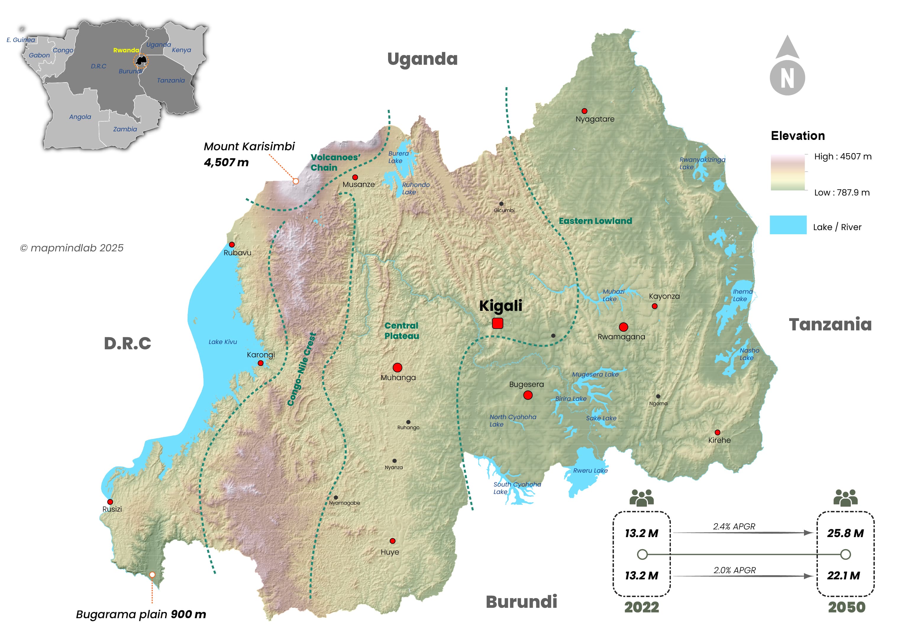
Fig.1: Location & Topographic Map of Rwanda
2. What is the NLUDMP
NLUDMP is a well-designed countrywide plan that allocates land to different uses by accumulating all thematic sectors, to manage the effective use of resources and guide the future development as well as by promoting more desirable socio, economic and environmental outcomes. It is also a national spatial or location-based plan that is structured around diverse thematic areas including: Population, urbanization and settlements, spatial economy (employment, manufacturing, industry and mining), Agriculture, Environment and natural resources, Tourism and conservation, Transportation, Infrastructure and Public service and so on. The NLUDMP also guides the implementation of land use planning, compliance, monitoring strategy and guidelines. In Rwanda, the first version of the NLUDMP spanning from 2012 to 2020 was developed to support the implementation of Vision 2020. Building on this, the second version, the NLUDMP 2020-2050, was elaborated to align with and facilitate the implementation of Vision 2050, ensuring sustainable land management and strategic development for the country’s long-term growth.
NLUDMP:
Is a national spatial, or location-based plan that is structure around all thematic sectors, to manage the effective use of land and resources and guide the future development by promoting balanced economy and more desirable socio, economic and environmental outcomes.
2.1. Adoption of NLUDMP 2011-2020
The Rwandan Cabinet adopted the first version of the NLUDMP in January 2011 as a strategic framework to determine actual land use, optimize resource allocation and facilitate national development from 2011 to 2020. This version was intended to support economic growth and infrastructure development by providing a patterned policy for land use and minimizing land use constraints. Ultimately, the NLUDMP 2011-2020 was originally framed with a five-year planning horizon, with a revision scheduled for 2015. This was to ensure that land use planning was in line with the implementation of the EDPRS II and the broader goals of Vision 2020. However, as the country progressed, challenges arose that necessitated revisions to the plan.
2.2. Adoption of NLUDMP 2020-2050
Following the implementation of the first version of the NLUDMP 2011-2020, an assessment and evaluation conducted by the Ministry of Environment through the former Rwanda Land Management and Use Authority (currently National Land Authority) in collaboration with key stakeholders identified several mismatches between the plan and the national strategic frameworks. The results revealed that the first version was not consistent with Vision 2050, the National Strategy for Transformation (NST1), the new Land Law, the Secondary City Approach, the Green Growth Policy and the sector databases managed by the national authorities. This assessment emphasized the urgent need for a revised and forward-looking land use plan that meets the country’s growing needs and is coherent with its long-term development targets. As a result, the government began elaborating the second version of the NLUDMP 2020-2050 in December 2018, which was completed in June 2020. This version introduced a more integrated and forward-looking approach to land use planning, ensuring that land resources are allocated efficiently to support sustainable urbanization, economic growth and environmental protection.
All land-users have been analyzed in parallel and influence each other to determine the land requirements for 2050. However, in a densely populated country like Rwanda, where land is scarce, there is constant competition and conflict between land users. To respond to this challenge, the plan employs economic and spatial considerations to create a balanced and sustainable land allocation framework that maximizes land efficiency while promoting national development. The NLUDMP 2020-2050 was formally approved by the Cabinet on 29 July 2020 and published on 23 May 2022 as a Presidential Decree in the Official Gazette No. 21 bis of 26 May 2022. This legal endorsement strengthens the plan’s role as a strategic national tool to guide land use planning, infrastructure development and environmental sustainability in line with Rwanda’s Vision 2050.
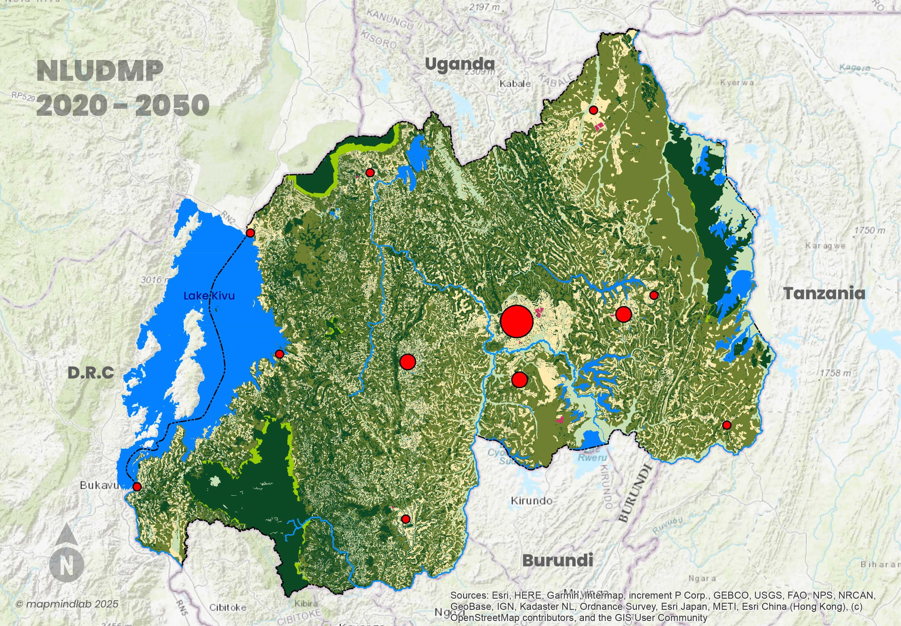 Fig.2: National Land Use and Development Master Plan 2020 - 2050
3. NLUDMP 2020-2050: A Key Driver of Vision 2050 Implementation
Vision 2050 sets ambitious targets for economic growth and national prosperity. Rwanda is to become an upper middle-income country (UMIC) by 2035 and a high-income country (HIC) by 2050. A key component of this vision is urbanization, with the goal of 70% of the population living in urban areas by 2050. To achieve this, the NLUDMP 2020-2050 has been strategically designed to align land use with the development goals of Vision 2050. The plan earmarked 101 urban areas to accommodate 70% of the projected 22.1 million population and ensure structured urban expansion, while at the same time accommodating 30% in planned rural settlement sites. By efficiently allocating land for economic, social and infrastructural development, the NLUDMP 2020-2050 serves as a foundation for sustainable growth and supports key sectors such as agriculture, industry, infrastructure and services. Its implementation ensures balanced economic progress that guides spatial planning, investment and resource management to ensure Rwanda’s long-term prosperity.
Basically, Vision 2050 required well-planned land allocation and the NLUDMP 2020-2050 serving as a roadmap to make this vision a reality.
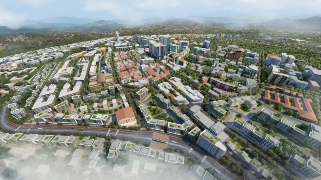 Fig.3: Kigali City Historical Commercial Node
4. Key Challenges before NLUDMP 2020-2050
Before the adoption of the NLUDMP 2020-2050, Rwanda faced significant land use challenges that hindered sustainable development, efficient resource management and balanced economic growth. These challenges led to inefficiencies in land allocation, environmental degradation and inter-sectoral land conflicts. The main issues that necessitated the development of a new comprehensive land use plan are highlighted below.
- 1. One of the biggest challenges was the outdated land use plan, which was not in line with national aspirations. The previous NLUDMP 2012-2020 was adopted in January 2011, long before the establishment of Vision 2050, the NST1, New Land Law, Secondary City Approach, Green Growth Policies and Updated National Development Strategies. As a result, it was not aligned with Rwanda’s evolving socio-economic and environmental priorities. This misalignment restricted appropriate urbanization, infrastructure development and economic zoning and led to inefficient land use.
- 2. Spread of Informal and Scattered Settlements: Due to rapid population growth and a growing exodus to the cities, many settlements grew without adequate planning. This led to difficulties in providing infrastructure such as roads, electricity and water, as well as limited access to key social services such as schools, hospitals and markets. These unplanned settlements were also often built in areas prone to flooding and landslides, making them vulnerable to natural disasters. Without a planned strategy, both urban and rural settlements expanded in a fragmented manner, making efficient integration of services difficult.
- 3. The Uncontrolled Urban Expansion was another pressing issue until the adoption of the NLUDMP 2020-2050. Cities and towns grew without coordinated land use regulations, leading to urban sprawl that made service delivery inefficient and costly. The lack of clear boundaries led to severe traffic blockages, inadequate transport networks and housing shortages in planned areas, forcing many people into informal settlements.As a result, urban development was lacking direction, which had a negative impact on economic growth and the quality of life of many residents.
- 4. The encroachment of agricultural land due to uncontrolled urbanization and scattered settlements: As the population continued to grow, agricultural land was increasingly converted into informal settlements and infrastructure projects, threatening food security as agricultural production declined. This unplanned destruction of fertile land also led to economic instability, as agriculture remains an important sector for rural livelihoods and national development. Beyond this, increasing competition for land between agriculture and settlement expansion led to land conflicts that hampered effective land management.
- 5. Encroachment of Environmentally Preserved Areas also posed a serious environmental threat. Wetlands, forests and protected ecosystems were gradually destroyed by the uncontrolled expansion of settlements and agriculture in ecologically sensitive areas. Deforestation for construction and agriculture has led to a loss of biodiversity, while the destruction of wetlands has reduced the natural water retention capacity and increased the risk of flooding. The lack of strict regulations for the designation of protected areas has led to significant environmental loss and reduced climate resilience.
- 6. The Mismanagement of Land Resources has proven to be a critical challenge. Land allocation was inconsistent and inefficient, leading to land speculation where investors hoarded land without developing it. Beyond this, unutilized land became a common problem, with many plots lying idle or misallocated, delaying potential development projects. Inadequate enforcement of property rights and unclear land ownership also contributed to disputes and made land governance ineffective.
- 7. Land use conflicts among different economic sectors: Different interests and economic sectors competed for the same land, resulting in overlapping demands from housing, agriculture, infrastructure development and nature conservation. This led to inconsistent planning across landscape and made it diffi:cult to efficiently allocate land for important projects. The lack of coordination also resulted in limited space for sectors growth, which restricted economic expansion and investment opportunities.
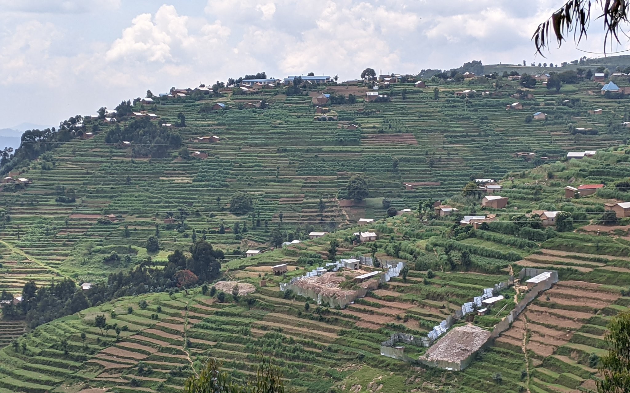 Fig.4: Settlement, Agriculture, and Mining Conflict
5. NLUDMP 2020-2050: A solution to address challenges highlighted
The NLUDMP 2020-2050 represents an integrated, foresight-driven plan to overcome land-use challenges in Rwanda, promoting sustainable development and ensuring balanced economic growth.
- 1. Alignment with National Development Goals: The NLUDMP 2020-2050 is fully integrated with Vision 2050, NST1, the new Land Law, the Secondary Cities approach, green growth policies and the updated National Development Strategies. This ensures that spatial planning supports national aspirations, drives sustainable urbanization and optimizes infrastructure development and economic zoning.
- 2. Planned and Compact Urban Development: To curb the expansion of informal and scattered settlements, the plan promotes compact, well-planned cities and planned settlements offering efficient services. This involves designated urban expansion areas, improved public infrastructure and affordable housing planned to accommodate population growth while reducing environmental threats.
- 3. Controlled and Coordinated Urban Expansion: The NLUDMP 2020-2050 introduces clear urban growth limits and strict land use regulations to prevent uncontrolled sprawl. By prioritizing transit-oriented development, mixed land-use planning and integrated mobility solutions, the plan enhances urban efficiency, improves connectivity and reduces congestion.
- 4. Controlled and Coordinated Urban Expansion: The NLUDMP 2020-2050 introduces clear urban growth limits and strict land use regulations to prevent uncontrolled sprawl. By prioritizing transit-oriented development, mixed land-use planning and integrated mobility solutions, the plan enhances urban efficiency, improves connectivity and reduces congestion.
-
5. Protection of Agricultural Land and Food Security: The plan enforces strict zoning rules to prevent unnecessary development in agricultural land. It promotes agro-urban integration, encouraging sustainable land-sharing practices and supporting modernized agriculture to boost productivity while maintaining a balance between urban expansion and food security.
- 6. Environmental protection and climate resilience: Recognizing the ecological importance of wetlands, forests and protected areas, the NLUDMP 2020-2050 establishes sound conservation policies. It includes nature-based solutions, afforestation programmes and buffer zones around environmentally sensitive areas to restore ecosystems, enhance biodiversity and mitigate climate risks such as flooding and landslides.
- 7. Effective Management of Land Resources: The NLUDMP 2020-2050 introduces effective land-use governance mechanisms to discourage speculation, encourage responsible land development and ensure security of tenure. Digital Land Management Systems, GIS-based monitoring and real-time tracking tools will improve transparency and ensure that land is used optimally to achieve economic and social benefits.
- 8. Integrated, Multi-Sectoral Land Use Development: To resolve land use conflicts between competing sectors, the NLUDMP 2020-2050 establishes a multi-agency coordination framework that reconciles the needs of Housing, Infrastructure, Agriculture, Industry and Environmental Conservation. This approach promotes synergy between different economic sectors, facilitating investment and sustainable land-use decisions.
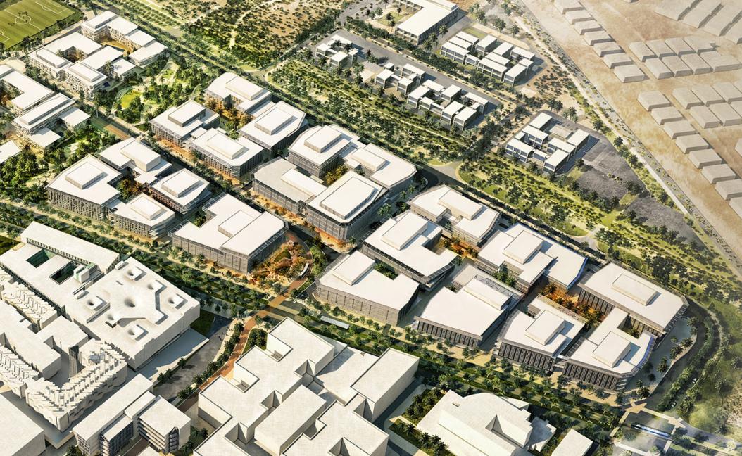 Fig.5: Planned and Compact Urban Development
6. NLUDMP 2020-2050: Bringing together all economic sectors for a balanced and sustainable economy
The NLUDMP 2020-2050 has brought together land-use planning across all key economic sectors, ensuring balanced growth and sustainable development in Rwanda. By integrating various sectors, the plan promotes efficient allocation of resources, reduces land conflicts and strengthens economic resilience.
6.1. PUSH (Population, Urbanization, Settlements and Housing)
The NLUDMP 2020-2050 has brought together land-use planning across all key economic sectors, ensuring balanced growth and sustainable development in Rwanda. By integrating various sectors, the plan promotes efficient allocation of resources, reduces land conflicts and strengthens economic resilience.
- 1. Well-Structured Urbanization: The plan promotes the development of organized and planned urban areas that are equipped to accommodate 70% of the growing population. By doing so, it reduces the risks of chaotic and uncontrolled urban sprawl, which can lead to congestion, inefficiency use of land, and environmental degradation.
- 2. Sustainable Settlement Patterns: NLUDMP 2020-2050 emphasize creating both urban and rural settlements that are environmentally friendly, socially inclusive, and economically viable. This involves integrating land use planning with transportation, employment opportunities, and access to basic amenities to support thriving communities.
- 3. Adequate and Affordable Housing: Recognizing housing as a basic human need, the plan allocates land for residential developments that cater to diverse income groups. Adequate housing ensures that the population has access to safe, affordable, and resilient living spaces.
- 4. Accessibility to Services and Infrastructure: The plan guarantees that settlements are strategically located to provide easy access to essential services such as education, healthcare, water, electricity, and transportation. This fosters equitable development and enhances the quality of life for all citizens.
- 5. Balanced Urban-Rural Development: To prevent over-concentration of economic activities in a few urban centers, the plan ensures equitable distribution of economic zones across the country. This approach supports rural development and reduces migration pressures on urban areas.
6.2. Spatial Economy (Employment, Manufacturing, Trade & Commerce, and Industrialization)
The NLUDMP 2020–2050 places a strong emphasis on aligning spatial land allocation with Rwanda’s economic ambitions. The spatial economy focuses on integrating employment opportunities, industrial development, commercial zones, and mining activities into the national land-use strategy to ensure sustainable economic growth, job creation, and diversification.
Key aspects of this thematic area include:
- 1. Industrial Growth Zones: Specific areas are earmarked for industrial parks and manufacturing facilities to promote industrialization. These zones are strategically located near transport corridors, utility infrastructure, and urban centers to enhance accessibility and operational efficiency.
- 2. Commercial Hubs: Land is allocated for business districts and commercial activities to support entrepreneurship, trade, and service sectors. These hubs provide vibrant spaces for commerce and economic interaction, contributing to overall development.
- 3. Mining Activities: Mining zones are carefully planned to ensure sustainable extraction of Rwanda’s natural resources while minimizing environmental impact. Land allocation considers proximity to mineral deposits and the need for infrastructure to support mining operations.
- 4. Employment Opportunities: The spatial allocation is driven by the aim to maximize job creation by situating industries, commercial hubs, and mining activities close to population centers. This ensures that economic benefits reach a wide portion of the population, while reducing commuting challenges.
6.3. Agriculture & Livestock
Agriculture and Livestock represent one of the nine thematic areas covered and analyzed under the NLUDMP 2020–2050. This sector is critical for ensuring food security, economic development, and the sustainable management of natural resources in Rwanda. Recognizing its importance, the plan strategically allocates land and resources to enhance agricultural productivity and support livestock farming as vital components for the country’s long-term development. The NLUDMP aims to address the demands of a projected population of approximately 22.1 million by 2050.
It emphasizes modern and efficient land use practices, introducing strategies such as:
- 1. Improved agricultural techniques to maximize crop yields.
- 2. Sustainable management of farmland to prevent soil degradation.
- 3. Allocation of specific zones for livestock farming to optimize production and ensure the well-being of animals.
- 4. Integration of agroforestry and mixed farming to strengthen resilience to climate change.
- 5. By prioritizing agriculture and livestock, the plan seeks to create a balanced approach to land use that not only supports Rwanda’s growing population but also promotes sustainability and economic growth for decades to come.
6.4. Environment & Natural Resources (Forests, Wetlands, Waterbodies, Mining, Waste and Stormwater Management)
The NLUDMP 2020–2050 places significant emphasis on preserving and sustainably managing Rwanda’s environment and natural resources. This thematic area emphasizes critical elements such as forestry, wetlands, water bodies, and stormwater management, integrating climate-resilient strategies to enhance biodiversity, mitigate disaster risks, and ensure sustainable development.
NLUDMP 2020-2050 determines how spatial allocation of land is addressed within this sector:
- 1. Ecologically Sensitive Zones: The plan designates protected areas for ecologically sensitive regions such as wetlands, forests, and water bodies. These areas are safeguarded from human activities that could lead to degradation, ensuring their ecological balance and contribution to the environment.
- 2. Reforestation and Afforestation: Land is allocated for reforestation projects and afforestation initiatives to combat deforestation and increase forest cover. This contributes to carbon sequestration, soil conservation, and enhanced biodiversity.
- 3. Wetland Conservation: Specific zones are identified for wetland preservation to maintain their ecological functions, such as water filtration, flood mitigation, and habitat provision for diverse species.
-
4. Water Bodies and Watershed Protection: The plan integrates the protection of lakes, rivers, and other water bodies, emphasizing sustainable land use around watersheds to prevent pollution and over-extraction of water resources.
6.5. Tourism & Conservation
The National Land Use Development Master Plan (NLUDMP) 2050 prioritizes tourism and conservation as critical components for sustainable growth and environmental stewardship. By identifying specific zones dedicated to tourism and conservation, the plan ensures the preservation of Rwanda’s cultural and natural heritage while fostering eco-friendly tourism practices that contribute to the nation’s economy.
Key highlights of tourism and conservation in the NLUDMP 2020-2050 include:
- 1. Dedicated Conservation Zones: The plan allocates land to protect and manage Rwanda’s iconic natural landmarks, such as national parks, forests, and other biodiversity hotspots. These zones aim to safeguard wildlife habitats, promote biodiversity, and mitigate the impact of human activities.
- 2. Eco-Tourism Development: Land is allocated to support eco-tourism initiatives that emphasize sustainability. These include areas for lodges, trails, and eco-friendly tourism infrastructure that allow visitors to experience Rwanda’s natural beauty while preserving its environment.
-
3. Cultural Preservation: The plan designates areas for cultural sites and heritage landmarks, ensuring the preservation and promotion of Rwanda’s rich history, traditions, and cultural identity. This fosters pride and awareness among locals while attracting international visitors.
- 4. Integration with Local Communities: Tourism zones are planned to integrate with local communities, providing employment opportunities and ensuring that economic benefits reach those living near tourist destinations.
6.6. Transportation
Transportation is a critical thematic area within NLUDMP 2020–2050, designed to support sustainable development, enhance mobility, and boost economic connectivity across Rwanda and the rest of the world. This sector emphasizes the designation and integration of a comprehensive, multi-modal transportation network.
Key components of the transportation theme include:
- 1. Roads and their reserves: Ensuring well-planned road networks with protected land reserves to allow future expansion, maintenance, and safety standards.
-
2. Bus stations and terminals: Strategically located infrastructure to facilitate efficient public transportation services and reduce congestion, particularly in urban areas.
- 3. Railways and their stations: Introducing or upgrading rail systems to connect regions, enhance the movement of goods and people, and promoting energy-efficient transit options.
- 4. Ports and airports: Optimizing air and water transportation infrastructure to support national and international trade while connecting Rwanda to global markets.
The NLUDMP 2020–2050 not only considers the physical infrastructure but also prioritizes transit-oriented development. This approach integrates land use planning with transportation systems, aiming to create compact, walkable urban spaces centered around transport hubs. This ensures accessibility, encourages economic activity, and promotes environmentally friendly transit solutions.
6.7. Public Facilities
NLUDMP 2020-2050 considers the following categories of public facilities: Education, Health, Administration, Religious Institutions, Sports, Culture, Cemeteries, and Memorial sites. The plan strategically allocates land for essential public facilities that support human activities and overall well-being. It ensures that these facilities are effectively positioned to meet the needs of the projected population by 2050 and beyond, fostering accessibility, sustainability, and community development.
This thematic area encompasses:
- 1. Education Facilities: Schools, universities, and vocational training centers are positioned to serve expanding communities and enhance equitable access to quality education.
- 2. Healthcare Infrastructure: Hospitals, clinics, and specialized medical centers are planned to ensure efficient service delivery and meet future health demands.
- 3. Administrative Centers: Government offices and civic institutions are structured to facilitate effective governance and decentralized service provision.
- 4. Religious Institutions: Spaces for worship and community gatherings, integrating cultural and social dimensions within planned urban and rural settlements.
- 5. Sports and Recreation Facilities: Stadiums, sports complexes, and recreational parks promote community well-being and physical activity.
- 6. Cultural Sites: Museums, heritage sites, and performance spaces preserve Rwanda’s rich history and artistic expression.
- 7. Cemeteries and Memorial Sites: Respectful allocation for burial grounds and national remembrance locations, maintaining dignity and historical significance.
6.8. Utilities (Water supply, Electricity, Landfills, ICT & Telecommunication etc...)
Utilities serve an integral part in the NLUDMP 2020-2050 by ensuring that essential services are strategically integrated into the country’s development framework. The plan prioritises the allocation of land for key infrastructure and ensures equitable access to clean water, reliable energy and advanced digital connectivity - critical elements for economic growth and improved quality of life.
This thematic area encompasses:
- 1. Water Supply Infrastructure: Planning for reservoirs, treatment plants, and distribution networks to guarantee access to clean water for households, industries, and agriculture.
- 2. Electricity Networks: Expanding power generation facilities, transmission lines, and substations to ensure efficient energy distribution and support economic activities.
- 3. ICT and Telecommunication Systems: Allocating space for broadband infrastructure, data centers, and telecommunications towers to enhance digital connectivity and technological advancement.
- 4. Landfills, dumpsites, and other waste management systems are integral components of the utilities segment within land use planning. They are essential for ensuring proper sanitation, environmental protection, and sustainable urban development.
-
7. Case study: Urbanization in Rwanda, a key thematic focus of NLUDMP 2020-2050
The NLUDMP 2020-2050 aims to guide Rwanda’s urbanization, envisioning a 70% urban population living in planned cities and rurbans by 2050, with the remaining 30% in planned rural settlements. Pre-colonial Rwanda saw scattered houses tied to agriculture. Colonization spurred small urban centers, and the post-genocide era prompted rapid urban growth, especially in Kigali, accommodating returnees. Scarce residential land, hilly terrain, and factors like low incomes led to unplanned urban expansion. Post-2004, Rwanda implemented resettlement programs like ‘imidugudu’ to organize people into planned areas. Policies such as the Urbanization policy and National human settlement policy were established to address housing challenges (Ngoga, 2015).
Rwanda, with Africa’s highest population density, faces the prospect of reaching 887 people/Km² by 2050. The population, growing at 2.4% annually, is expected to reach 22.1 million by 2050, placing significant demands on resources. Despite rapid urban growth, Rwanda’s urbanization rate remains low. Between 2002 and 2022, the urban population increased from 1.49 million to 3.7 million, growing at an average rate of 6.7% per year (Habitat, Accessed in 2023). Primacy syndrome characterizes Rwanda’s urbanization, a relic of colonial history. To address this, the NLUDMP 2020 - 2050 introduces “In-Situ Urbanization,” transforming rural clusters into urban centers. This process reduces migration to cities, preventing pressure on existing towns.
The NLUDMP 2020-2050 introduces a settlement hierarchy, including the capital city, satellite cities, secondary cities, District towns, and rurban centers, aiming for balanced and sustainable development based on population distribution and economic potential.
The goal is a 70% urbanization rate by 2050, achieved through in situ urbanization and strategic investments in the rural system. Furthermore, all cities and rurban/emerging centers are required to have diverse land uses, including residential, commercial, tourism, and conservation areas, urban farming, urban forests, landscaping, social services like sports and recreational facilities, schools, health facilities, transportation, and religious facilities.
Cities are mandated to initiate urban renewal projects and reassess the utilization of steeper slopes within existing settlement boundaries, encouraging infill development, consolidation, and more affordable housing options for migrants. The emphasis is on densification and urban renewal to replace sprawl, which often results from the simpler and less expensive development in vacant areas. The plan advocates two complementary concepts, Agglomeration and Consolidation, where agglomeration is suitable for services and the economy. Spatial consolidation is crucial for the emergence of agglomeration and economies of scale. Concentration and consolidation serve as alternatives to sprawl, representing key objectives of the plan.
The National Urbanization Policy of 2015 comprehensively addresses cross-Sectoral actions in urban development and governance for sustainable development. Its primary goals are to enhance collaboration and cooperation among all stakeholders and communities to improve service provision and support a growing local economy continually. The policy establishes a framework guiding urbanization through its four main pillars: Coordination, Densification, Sociality, and Economic Growth.
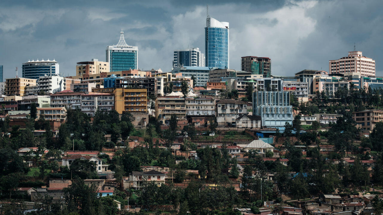 Fig. 13: Kigali - The Capital City of Rwanda
8. Rwanda Urbanization Hierarchy
The NLUDMP 2020-2050 established a structured urbanization hierarchy with corresponding population distributions for each urban category. This framework is designed to optimize the efficient use of land and resources to ensure sustainable urban growth. Rwanda’s urbanization hierarchy has been strategically developed to accommodate 70% of the projected population of 22.1 million by 2050, promoting well-planned, resilient and inclusive urban development across the country.
This hierarchy starts from Kigali, the capital city, which is planned to lead the country’s central economic and political power and accommodate around 3 to 3.8 million inhabitants. The city of Kigali is supported by three satellite cities - Muhanga, Bugesera and Rwamagana - one of which will be home of between 650,000 and 1 million inhabitants. The satellite city of Muhanga was established to support Kigali, mainly in the areas of trade and mining. Bugesera was introduced to support Kigali in transportation by import/export and logistics, supported primarily by Bugesera International Airport. Rwamagana was introduced as a satellite city to serve as an agricultural hub, as the Eastern Province has potential for agriculture given its favorable topography and fertile soil. Kigali, along with the three satellite cities, forms a strategically significant urban network known as the Golden Triangle. This designation highlights the interconnected development of these cities, creating a dynamic economic and infrastructural hub that drives Rwanda’s urbanization, investment, and regional connectivity.
Following the satellite cities, the NLUDMP 2020-2050 has also introduced 8 secondary or peripheral cities, which are intended to support the country mainly in terms of cross-border trade with neighboring countries and boost the economy on the country’s outskirts. Each of these secondary cities will be home to between 250,000 and 650,000 people. Nyagatare serves as a gateway to Uganda via Kagitumba border, facilitating trade and crossborder movement, while Musanze is another important linkage to Uganda via Cyanika border, supporting tourism in Volcanoes’ NP and supporting trade. Rubavu serves as a trade and logistics hub to the DRC via Goma, while Rusizi serves as a major entry point to Bukavu in the DRC, supporting economic ties and regional trade. Huye provides a direct access to Burundi via Akanyaru border, facilitating trade and cultural exchange. Karongi, located along the Kivu Belt, is a major tourism destination and connects to Idjwi Island in DRC via Lake Kivu, promoting ecotourism and cross-border trade. Kirehe is linked to Tanzania through the Rusumo border, thereby strengthening trade routes within the East African region. Kayonza, located at the junction of the Eastern Expressway, serves as a strategic gateway to Akagera National Park, promoting tourism and regional mobility. These secondary cities are planned to promote balanced urbanization, economic diversification and infrastructure development, supporting Rwanda’s vision of becoming a prosperous and highly developed nation by 2050.
NLUDMP 2020-2050 has also identified 16 District Towns distributed across the country. These urban centers have been strategically established in districts outside of Kigali City, satellite cities and secondary cities. Each District Town is projected to accommodate between 100,000 and 250,000 residents and will serve as a central part of the national urbanization efforts and promote balanced regional development in these specific districts.
The urbanization effort in the country extending beyond the abovementioned urban areas continues with the establishment of 73 rurban centers, which are emerging centers within their respective districts to support the transformation from rural to urban living in their localities. These rurban centers will be home to between 20,000 and 100,000 people. Altogether, the NLUDMP 2020 - 2050 envisages that Rwanda features a total of 101 urban areas, which are planned to accommodate 15.4 million inhabitants (70%).
Consequently, besides these 101 urban areas of the country, the population is planned to settle in planned rural settlements sites of around 3,000 sites according to the recommendations of the NLUDMP 2020 - 2050. These sites are set to accommodate 6.7 million inhabitants, or 30% of the country’s total projected population by 2050. Together, 101 urban areas and roughly 3,000 planned rural settlement sites, coupled with all infrastructure supporting human habitation, account for 15.1% of the country’s total land area. The remaining land outside this hierarchy of urbanization and settlement is reserved for non-settlement activities including agriculture and livestock, forestry and conservation, mining, tourism, water, wetlands, etc.
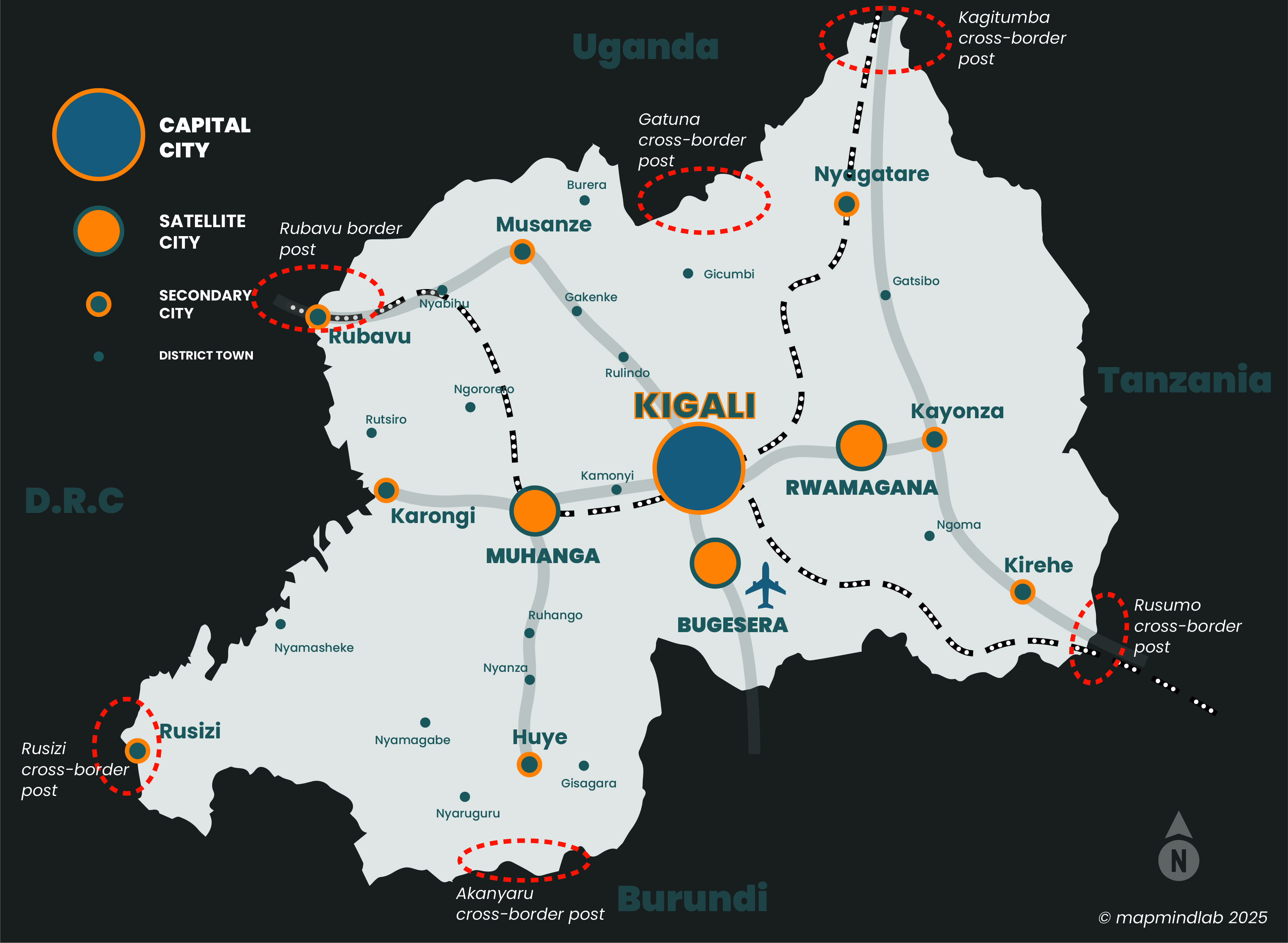 Fig. 13: Spatial urbanization hierarchy of Rwanda according to NLUDMP 2020-2050
9. National Land Allocation (Land Use Balance Sheet)
The NLUDMP 2020-2050 defines a comprehensive strategic framework for the balanced allocation of the total land area of the country (26,338 km²), structured into four main categories: Agriculture and Livestock, Forestry and Conservation, Urbanization & Settlement and Infrastructure, and Water Bodies, Protected Wetlands and their Buffer Zones. The integrated nature of these categories ensures efficient land use, sustainable development and environmental resilience, promoting harmonized economic growth while preserving natural ecosystems. This structured approach paves the way for a well-planned and prosperous future for Rwanda.
Agriculture and livestock account for 12,433 km² (47.2%) of Rwanda’s total land area, making it the dominant land use category under NLUDMP 2020-2050. This allocation encompasses agriculture, livestock farming, apiculture, and pisciculture, supporting both food security and economic sustainability. Agricultural land covers crop cultivation, horticulture, and agro-industrial development, while livestock areas accommodate cattle, goats, pigs, poultry, and other domestic animals. Beekeeping and fish farming further diversify land use within this category. The NLUDMP 2020-2050 framework promotes climate-smart agricultural practices, ensuring efficient land utilization, rural development, and long-term environmental sustainability.
The Forest and Conservation category, covering 7,725 km² (29.3%) of Rwanda’s land under the NLUDMP 2020-2050, includes various ecological and forested zones essential for environmental sustainability and biodiversity conservation. This category comprises Natural Forest Zones, Plantation Forest Zones, Re-afforestation Zones, and National Parks Zones, along with their designated buffers. These zones collectively contribute to climate resilience, habitat preservation, sustainable forestry, and eco-tourism, ensuring balanced environmental management in line with Rwanda’s long-term development goals.
Urbanization, settlements, and related infrastructure occupy 3,980 km² (15.1%) of Rwanda’s total land area under NLUDMP 2020-2050. This category encompasses built-up areas, planned urban and rural settlements, and essential infrastructure. By 2050, Rwanda is projected to be predominantly urbanized, with 70% of the population residing in urban areas and 30% in planned rural settlement sites. This land allocation includes all public facilities and utilities, such as schools, hospitals, government institutions, markets, sports complexes, cultural heritage sites, and cemeteries. Additionally, it covers critical infrastructure, including roads, electricity grids, ICT systems, and water supply networks. NLUDMP 2020-2050 emphasizes well-planned urban growth, smart cities, and resilient infrastructure to enhance economic productivity and overall quality of life.
Waterbodies, protected wetlands, and their buffer zones occupy 2,200 km² (8.5%) of Rwanda’s total land area under NLUDMP 2020-2050. This allocation includes lakes, rivers, wetlands, and their designated buffer zones, ensuring the conservation of water resources and ecological stability. These areas support flood control, biodiversity conservation, and climate resilience, with buffer zones established to prevent environmental degradation. Protected wetlands play a crucial role in carbon sequestration and the preservation of aquatic ecosystems, contributing to Rwanda’s sustainable land and water management strategies.
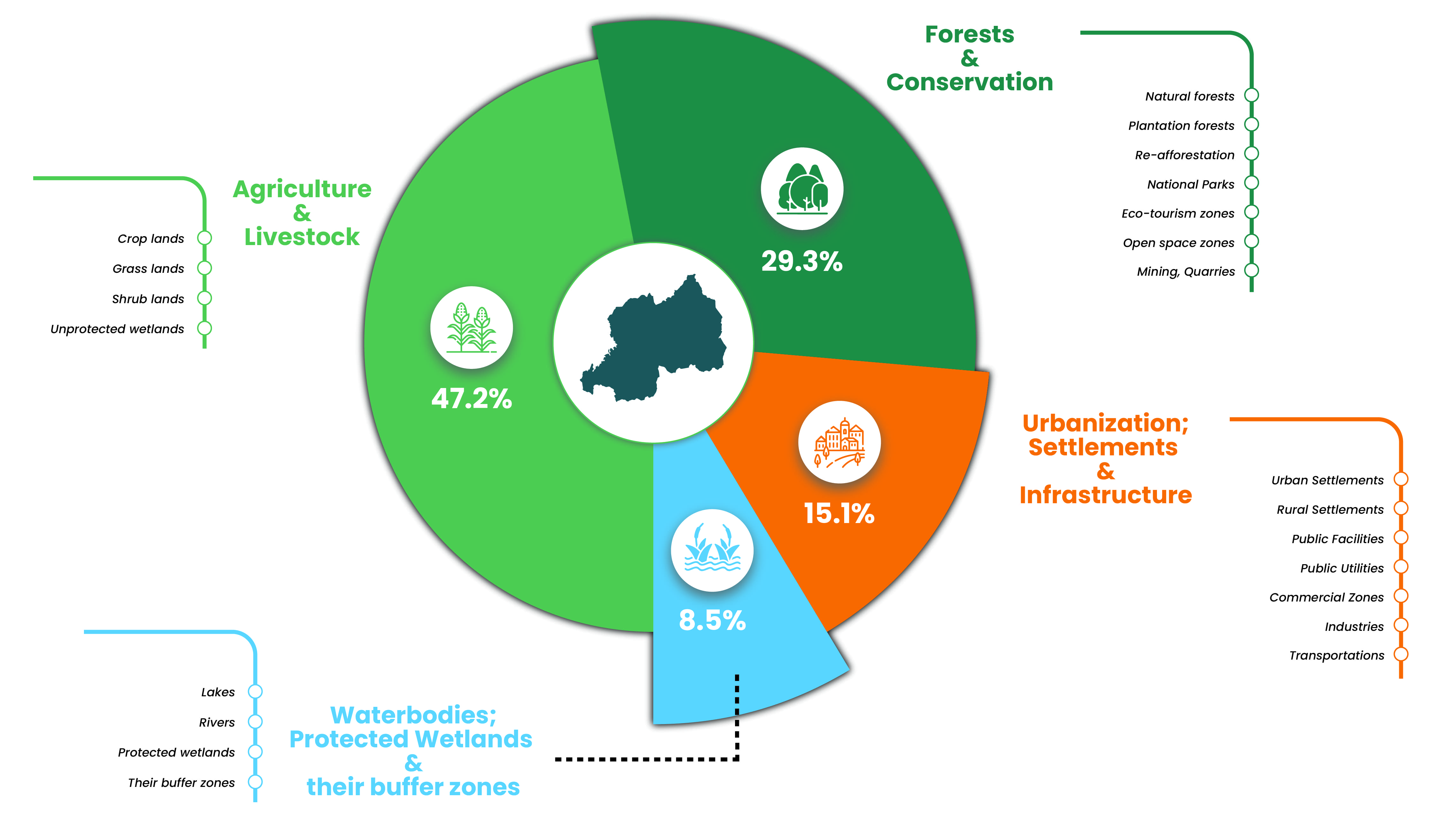 Fig. 13: Spatial urbanization hierarchy of Rwanda according to NLUDMP 2020-2050
10. Implementation of the NLUDMP 2020-2050
The NLUDMP 2020-2050 as a national plan provides general guidelines for land use planning in Rwanda. However, due to the country’s diverse economic specializations and urbanization patterns, implementation of the plan requires a decentralized approach, ensuring that land use planning is effectively tailored to the district level.
10.1. Elaboration of District Land Use Plan (DLUP)
Implementing the NLUDMP 2020-2050 requires the critical step of turning the national vision into localized strategies at district level. The first part of this process is the development of District Land Use Plans (DLUPs), which break down the broader objectives of the NLUDMP into achievable plans for each district. The DLUP is basically a detailed adaptation of the NLUDMP, focusing specifically on the land within each district, ensuring that every parcel of land is accounted for and allocated to a specific use.
The DLUP covers both urban and rural areas within the district boundary, ensuring comprehensive planning that leaves no land unplanned. The aim of the DLUP is to allocate land to a variety of uses according to the unique needs and potential of the district, while having regard to the broader targets of the NLUDMP 2020-2050. DLUPs are developed by pulling together all the thematic areas within the district, such as agriculture, forestry, urbanization, transportation, conservation and industrialization, into a single plan. Each thematic area is analyzed and integrated to ensure the coherence of the plan and to support sustainable development practices.
For Kigali, the capital city of Rwanda, the implementation of the NLUDMP 2020-2050 called for the elaboration of Kigali City Master Plan, which aligns with the national objectives and envisages the transforming Kigali into a more urbanized and sustainable city. For districts outside Kigali, clustered DLUPs are being developed based on the economic strengths of each district, considering their different levels of urbanization and sectoral needs. These clustered plans allow for tailored land use strategies that promote sustainable development and address the unique challenges of each district.
The DLUP is initially developed with a short-term target for 2035, which serves as the first phase of implementing the NLUDMP 2020-2050. The 2035 target sets a clear and manageable timeline, allowing local authorities to focus on immediate land use needs and priorities. This first phase establishes the foundation of the land use plan by addressing the current land use situation, urbanization trends, and other sectoral needs in each district. Once the 2035 target is achieved, the DLUP will be revised for the 2050 target, aligning with the broader long-term vision of the NLUDMP. The revision process allows for adjustments based on evolving economic, social, and environmental factors, ensuring that the plan remains relevant and responsive to changes over time.
This two-phase approach ensures that the implementation of the NLUDMP is not only realistic and practical but also adaptable to future needs and opportunities. By breaking down the implementation into these two manageable phases, the plan provides a structured pathway for development that supports both immediate and long-term goals. The 2035 target serves as a steppingstone, with the 2050 target providing the ultimate vision, allowing for a balanced and sustainable land use strategy that can evolve and be refined as the country progresses toward its long-term development goals.
10.2. Development of Land Use Plan Zoning Regulations
Land Use Zoning Regulations are a key component of the implementation of the NLUDMP 2020-2050, providing clear guidelines and control over how land within a given area can be developed and used. The zoning plan, which is central to this process, consists of two main components: the zoning map and the zoning regulations.
The zoning map visually identifies specific zones within the planning area, with each zone representing the predominant land use (e.g. residential, commercial, industrial, agricultural, etc.). It also specifies the desired building characteristics for each zone, including allowable building height, density and other physical characteristics. This map acts as a blueprint for how land in different areas should be developed, ensuring that land use is consistent with the overall vision of the NLUDMP 2020-2050. The zoning regulations set out the rules for development within each zone. These regulations determine the type of land use, intensity of development, density, location and permitted height of buildings in a given area. They are designed to ensure that land use is consistent with the objectives of the National Master Plan, while promoting organized and sustainable urban growth.
There are three primary categories of land use under the Zoning Regulations:
- 1. Permitted Use: These are the land uses that are consistent with the designated zoning code and are permitted outright. In other words, these uses are automatically allowed in a specific zone, provided the development complies with the specified regulations. For example, in a residential zone, single-family homes or apartment building may be considered permitted use.
- 2. Conditional Use: These are activities that, although they may be compatible with the general intent of the zoning code, could have potential impacts such as increased traffic, noise, or other disturbances in the surrounding neighborhood. These uses are not automatically permitted; instead, they require an assessment and approval from the relevant local authorities, such as the City of Kigali (CoK) or the District Oversight and Supervision Committees (OSCs). Examples of conditional uses may include larger commercial developments or facilities that could impact nearby residents.
- 3. Prohibited Use: These are the land uses that are strictly forbidden within a given zone. Such uses are considered incompatible with the intended character or purpose of the zone. For instance, heavy industrial activities would be prohibited in a residential zone, as they could disrupt the quality of life for residents due to noise, pollution, and other impacts.
By establishing these zoning categories, the Land Use Zoning Regulations serve to create a structured and organized approach to development. They ensure that growth is well managed, minimizing conflicts between different land uses and supporting the wider objectives of sustainability, efficiency and quality of life within communities. By implementing these regulations, Rwanda can achieve its urbanization targets in line with the NLUDMP 2020- 2050 and promote a balanced and resilient built environment.
REFERENCES
- 1. Government of Rwanda. (n.d.). Geography. Retrieved from About Rwanda
- 2. Wikipedia contributors. (n.d.). Rwanda. In Wikipedia, The Free Encyclopedia. Retrieved from https://en.wikipedia.org/wiki/Rwanda
- 3. NISR. (2023). Main indicators: 5th Rwanda Population and Housing Census (PHC). Kigali, Rwanda: National Institute of Statistics Rwanda. Retrieved from RPHC5, 2022
- 4. NLA. (2022). Population growth and land requirements in Rwanda. Kigali, Rwanda: National Land Authority. Retrieved from NLUDMP 2020-2050
- 5. NLA. (2022). National Land Use and Development Master Plan 2050. Kigali, Rwanda: National Land Authority. Retrieved from NLUDMP 2020-2050
- 6. Munyaneza, J. P., Rwema, P., Ndolimana, E., Nzayinambaho, J., Nsanzumukiza, M. V., & Barahira, A. (2023). The Impact of Urbanization Expansion on Agriculture Land in Rwanda: Case Study of Runda Sector, Kamonyi District. American Journal of Environmental Protection, Science Publishing Group. Retrieved from sciencepublishinggroup.com/
- 7. Nsangabandi, E., & Mupenzi, C. (2020). Assessing the Impact of Urban Growth on Agricultural Land in Gasabo District: A Case Study of Ndera Sector. East African Journal of Science and Technology, University of Lay Adventists of Kigali (UNILAK). Retrieved from eajst.unilak.ac.rw
- 8. Kuradusenge, J. M. V., & Maniragaba, A. (2018). Assessment of Urban Sprawl and Agricultural Land in Musanze City Using Remote Sensing and GIS Technologies. East African Journal of Science and Technology, University of Lay Adventists of Kigali (UNILAK). Retrieved from eajst.unilak.ac.rw
Leave a Comment
Comments (0)