

Commercial-oriented Agriculture and Tourism
Ngoma District is one of the seven districts forming Rwanda’s Eastern Province, covering an area of 867.74 km². Administratively, the district is composed of 14 sectors, 64 cells, and 473 villages (imidugudu). These sectors include Gashanda, Jarama, Karembo, Kazo, Kibungo, Mugesera, Murama, Mutenderi, Remera, Rukira, Rukumberi, Rurenge, Sake, and Zaza (source: Ngoma District). The District Headquarters is located in Ngoma District Town (Kibungo Urban Area), a strategic and rapidly growing urban node positioned along the planned Rwandan Eastern Expressway, a major regional transport corridor linking Rwanda to Tanzania via Rusumo Cross-border. This location makes Ngoma District a significant gateway for trade, and regional integration.
Geographically, Ngoma District shares borders with Bugesera District to the west, Rwamagana to the north, Kayonza to the northeast, Kirehe to the east and southeast, and Burundi to the south, placing it at the crossroads of several major economic and cultural zones. The district is endowed with picturesque lakes such as Mugesera, Sake, and Birira, which define its western landscape and hold immense potential for eco-tourism and recreation. Lake Mugesera, in particular, stretches across the border with Rwamagana, forming a vast natural asset for both environmental conservation and leisure development.
Ngoma District landscape blends fertile agricultural plains, wetland systems, and moderate hills, supporting a largely agrarian economy while offering opportunities for irrigation, agro-processing, and tourism development. Innovative initiatives such as solar-powered irrigation schemes introduced in sectors like Jarama, Murama, and Sake are transforming livelihoods and boosting productivity, especially for women farmers.
Overall, Ngoma District represents a critical component of Rwanda’s eastern development corridor, combining agricultural strength, regional connectivity, and environmental richness to position itself as a future agro-economic and trade hub in line with the country’s Vision 2050.
1. Ngoma District
Ngoma District is one of the seven districts forming Rwanda’s Eastern Province, covering an area of 867.74 km². Administratively, the district is composed of 14 sectors, 64 cells, and 473 villages (imidugudu). These sectors include Gashanda, Jarama, Karembo, Kazo, Kibungo, Mugesera, Murama, Mutenderi, Remera, Rukira, Rukumberi, Rurenge, Sake, and Zaza (source: Ngoma District). The District Headquarters is located in Ngoma District Town (Kibungo Urban Area), a strategic and rapidly growing urban node positioned along the planned Rwandan Eastern Expressway, a major regional transport corridor linking Rwanda to Tanzania via Rusumo Cross-border. This location makes Ngoma District a significant gateway for trade, and regional integration.
Geographically, Ngoma District shares borders with Bugesera District to the west, Rwamagana to the north, Kayonza to the northeast, Kirehe to the east and southeast, and Burundi to the south, placing it at the crossroads of several major economic and cultural zones. The district is endowed with picturesque lakes such as Mugesera, Sake, and Birira, which define its western landscape and hold immense potential for eco-tourism and recreation. Lake Mugesera, in particular, stretches across the border with Rwamagana, forming a vast natural asset for both environmental conservation and leisure development.
Ngoma District landscape blends fertile agricultural plains, wetland systems, and moderate hills, supporting a largely agrarian economy while offering opportunities for irrigation, agro-processing, and tourism development. Innovative initiatives such as solar-powered irrigation schemes introduced in sectors like Jarama, Murama, and Sake are transforming livelihoods and boosting productivity, especially for women farmers.
Overall, Ngoma District represents a critical component of Rwanda’s eastern development corridor, combining agricultural strength, regional connectivity, and environmental richness to position itself as a future agro-economic and trade hub in line with the country’s Vision 2050.
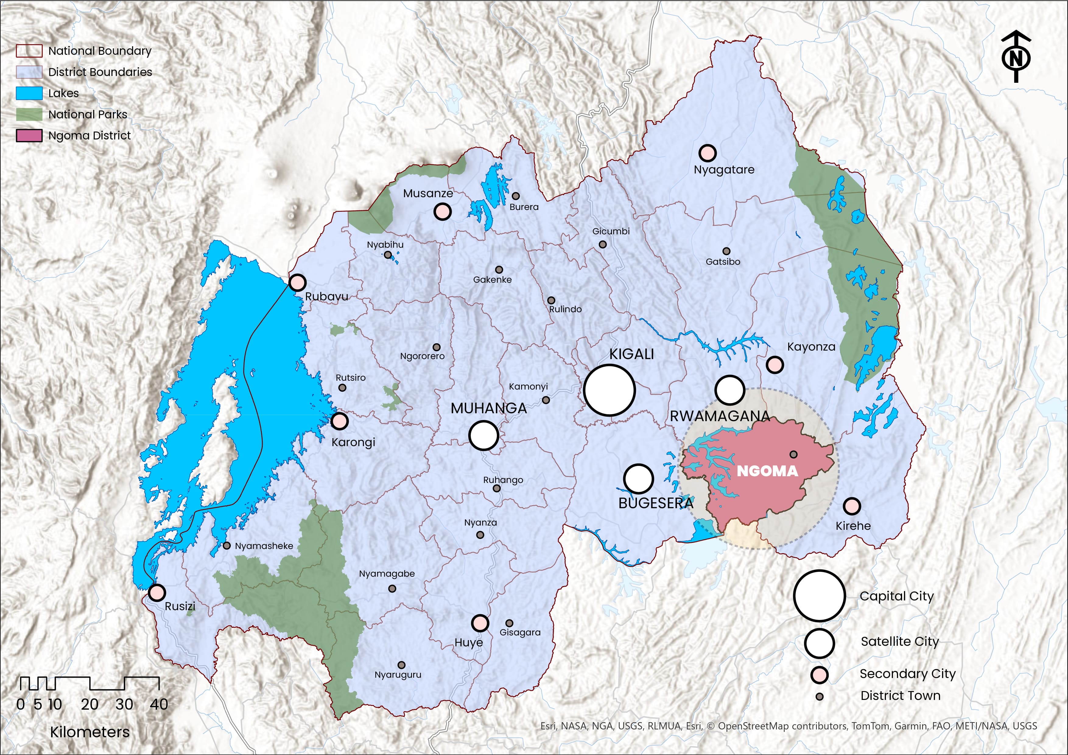 Geographical Location of Ngoma District
- 2. Ngoma DLUP
District Land Use Plan (DLUP):
Is a geographical or spatial strategic plan that translates the NLUDMP 2020–2050 into actionable framework at the district level, guiding the effective allocation and management of land and resources across all thematic sectors, for efficient, sustainable, and conflict-free land use to promote a balanced economy, environmental stewardship, and socio-economic transformation for both present and future generations.
Ngoma DLUP is a comprehensive spatial strategic plan developed to turn the NLUDMP 2020–2050 into a localized and actionable tool for sustainable land management in Ngoma District. The plan was elaborated through an In-House Capacity approach by the NLA in close collaboration with Ngoma District, between 2022 and 2023. It was elaborated using a rigorous, participatory, and data-driven methodology, involving extensive consultations from the national to the community level, systematic collection and analysis of spatial and non-spatial data, and the integration of both technical expertise and local knowledge into a coherent planning framework.
At the core of Ngoma DLUP lies the District Economic Specialization, which identifies Ngoma District unique comparative advantages and anchors its long-term vision toward 2050. This vision emphasizes sustainable land use, planned urban growth, and inclusive socio-economic transformation. The plan integrates population projections to ensure that land allocation, infrastructure, and service delivery systems are responsive to both current and future needs. It also aligns the urbanization and settlement hierarchy from Ngoma District Town as the main urban area to supporting emerging centers and rural settlements sites with national spatial planning strategies and policies.
In alignment with the NLUDMP 2020–2050, the plan adopts the recommended housing typologies, defines the residential housing stock by zoning categories, and establishes a Land Use Balance Sheet for 2050 to guide balanced and efficient land distribution among key thematic sectors. Furthermore, it identifies catalytic projects that will accelerate economic transformation through enhanced infrastructure, agribusiness value chains, tourism development, and improved social services.
Following its elaboration, Ngoma DLUP underwent several stages of technical review, public display, validation, and approval, including endorsements from the District Council, Technical Advisory Group (TAG), Economic Cluster, and the Cabinet. Upon approved from the District Council, the plan started serving as a guiding instrument for spatial development, investment promotion, and sustainable growth, steering the district toward its vision as a regional hub for agribusiness, trade, and eco-tourism in Rwanda’s Eastern Province.
3. Economic Specialization
| Economic Specialization | Why? |
|---|---|
| Agribusiness | Ngoma District’s flat terrain, fertile soils, and favorable climate make it a key agricultural hub in Eastern Rwanda, producing rice, maize, bananas, and pineapples that fuel a growing agribusiness sector driven by rice milling, banana wine, maize, and dairy processing, boosting productivity, jobs, and local economic growth. |
| Tourism | The western lake network and the scenic rock above Nasho in Rukira Sector, along with Ngoma District diverse historical, cultural, and heritage sites, present remarkable eco-tourism potential through nature-based experiences and cultural attractions. |
| Strategic Trade, Commerce and Logistics Corridor | Positioned between Kayonza and Kirehe along the Eastern Expressway to Rusumo, Ngoma District serves as a strategic trade and logistics corridor linking Rwanda and Tanzania, further strengthened by the planned railway station in Sake–Rukumberi along the proposed Rwanda–Tanzania railway line. |
Ngoma District economic specialization is anchored in its strong agricultural base, strategic location, and emerging tourism potential, all contributing to its role as a vital growth pole in Rwanda’s Eastern Province. Agriculture remains the cornerstone of the local economy, supported by fertile soils, flat terrain, and a favorable climate that enable extensive cultivation of rice, maize, beans, bananas, and pineapples. This agricultural abundance feeds into a growing agribusiness sector, with increasing opportunities for value addition through rice milling, banana wine production, maize processing, and dairy enterprise, transforming raw farm produce into market-ready products and stimulating employment and income generation.
The district’s natural assets further strengthen its tourism potential, with the interconnected lakes of Mugesera, Sake, and Birira in the west providing scenic and ecological value, while the unique rock formation above Nasho in Rukira Sector presents opportunities for hiking and eco-cultural tourism. Complementing these sectors, Ngoma District’s strategic position between Kayonza and Kirehe along the planned Eastern Expressway connecting Rwanda to Tanzania via Rusumo border strengthens its role as a regional trade and logistics corridor, further reinforced by the proposed railway station in Sake–Rukumberi along the Rwanda–Tanzania railway line positioning the district as a dynamic economic gateway facilitating cross-border commerce and regional connectivity.
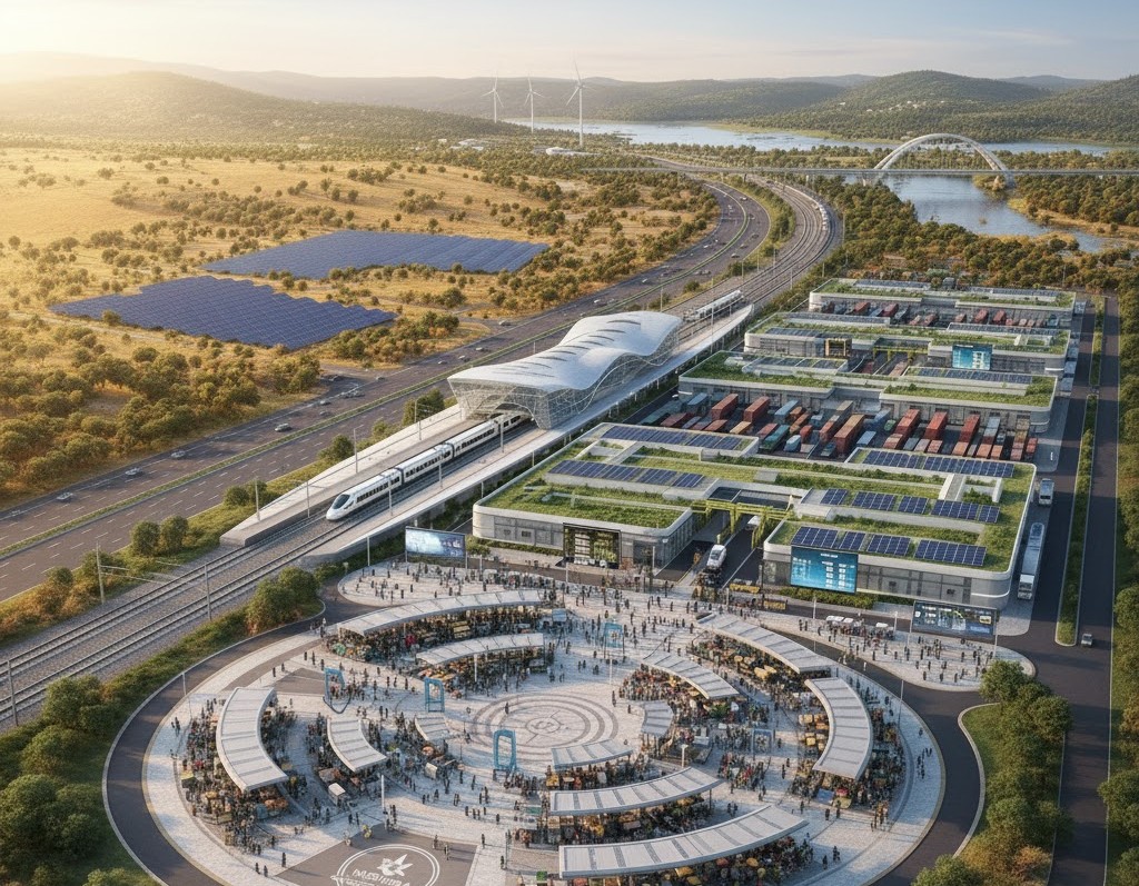 Visionary Picture of Sake–Rukumberi Planned Railway Station and Logistics Hub
4. Vision
Vision of Ngoma District is to become:
Commercial-oriented Agriculture and Tourism
The vision “Commercial-oriented Agriculture and Tourism” for Ngoma District is a direct outcome of its economic specialization, which is deeply rooted in its strong agricultural base, strategic location, and emerging tourism potential. Agriculture forms the backbone of Ngoma District economy, supported by fertile soils, flat terrain, and favorable climatic conditions that sustain the cultivation of rice, maize, beans, bananas, and pineapples. Building on this strength, the district seeks to transform traditional subsistence farming into a market-driven, value-added agricultural system, promoting agribusiness activities such as rice milling, banana wine production, maize processing, and dairy enterprises. This approach aims to enhance productivity, create employment opportunities, and strengthen income generation through commercialized agriculture, supported by improved access to regional and cross-border markets via the planned Eastern Expressway linking Rwanda to Tanzania.
At the same time, the tourism component in Ngoma District derives from its natural and cultural endowments, which include the scenic lakes of Mugesera, Sake, and Birira, and the unique rock formation in the junction of Ngoma, Kirehe and Kayonza (above Nasho) in Rukira Sector. These assets offer significant potential for eco-tourism, cultural exploration, and recreation. The district’s strategic location enhances its accessibility, making it a potential gateway for visitors traveling within the Eastern Province and beyond. By integrating agriculture and tourism, Ngoma aims to foster mutually reinforcing sectors where agricultural products support tourism experiences, such as agro-tourism and local cuisine, while tourism creates new markets and visibility for local producers. Together, these dynamics embody Ngoma District aspiration to become a vibrant, commercially oriented, and sustainable economic hub driven by agriculture and tourism.
5. Population Projection
| District Population | 2012 | 2022 | 2035 | 2050 |
|---|---|---|---|---|
| Urban Population | 15,236 (4.5%) | 37,297 (9.2%) | 133,043 (30.6%) | 253,000 (53.5%) |
| Rural Population | 321,692 (95.5%) | 366,751 (90.8%) | 301,670 (69.4%) | 220,000 (46.5%) |
| Total Population | 336,928 | 404,048 | 434,714 | 473,000 |
Ngoma District Population Projection | Source: NISR (RHPC 5, 2022); NLA (NLUDMP 2020-2050; Ngoma DLUP)
Ngoma District Population Projection as presented in the table above provides a detailed outlook of demographic changes from 2012 to 2050, illustrating both the growth in total population and the shifting balance between urban and rural populations. The data highlights the district’s ongoing demographic transformation, marked by significant urbanization and gradual reduction of rural dominance.
In 2012, Ngoma District had a total population of 336,928 people, with 15,236 (4.5%) residing in urban areas and 321,692 (95.5%) in rural areas. By 2022, the population rose to 404,048, indicating a steady growth over the decade. Urban residents increased more than double to 37,297 (9.2%), while the rural population also grew slightly to 366,751 (90.8%). This shows an emerging trend of urban migration and expansion of town centers. Looking ahead, projections for 2035 estimate the population to reach 434,714, with the urban population expected to rise sharply to 133,043 (30.6%), while the rural population will decline proportionally to 301,670 (69.4%). By 2050, the district’s population is projected to reach 473,000, with an even more dramatic demographic shift — 253,000 (53.5%) living in urban areas compared to 220,000 (46.5%) in rural zones.
This progression clearly indicates that Ngoma District is transitioning from a predominantly rural district to a largely urbanized one by 2050. The sharp increase in urban population is likely driven by ongoing infrastructure development, economic diversification, and regional integration, particularly along the planned Eastern Expressway connecting Rwanda to Tanzania. The rural population’s gradual decline reflects both the effects of urban migration and the modernization of agriculture that may require fewer but more skilled laborers. Overall, these projections emphasize the need for strategic urban planning, service delivery, housing, and infrastructure development to accommodate rapid urban growth, while ensuring sustainable rural transformation and balanced territorial development within the district.
6. Urbanization and Settlements
| Settlement Hierarchy | Name (s) | Number | Area (Km²) | Population | Density (Inh./Km²) |
|---|---|---|---|---|---|
| District Town | Ngoma District Town | 1 | 16.8 | 200,000 | 11,905 |
| Rurban Center (s) | Sake, Rukira | 2 | 12.4 | 53,000 | 4,274 |
| Rural Settlements Sites | - | 45 | 75.4 | 220,000 | 2,917 |
Urbanization & Settlements in Ngoma District by 2050 | Source: NLA (NLUDMP 2020-2050; Ngoma DLUP)
Ngoma District is among the 16 districts in Rwanda categorized as having a District Town as their main urban area, positioning it as a key urban growth and service hub within the Eastern Province. Importantly, its urbanization pattern follows a structured three-tier hierarchy composed of the District Town, Rurban Centers, and Rural Settlement Sites, designed to promote balanced spatial development and efficient land management in alignment with the NLUDMP 2020–2050.
Serving as the primary urban center, Ngoma District Town is the administrative, commercial, and service capital of the district. According to the NLUDMP 2020–2050, its urban area was projected to expand from 16 km² in 2035 to 43 km² by 2050, accommodating a population of about 200,000 at a density of 4,651 inhabitants/km². The DLUP 2023–2050, however, introduces a more compact and sustainable approach, proposing an area of 16.8 km² for the same target population, achieving a higher density of 11,905 inhabitants/km². This shift reflects the district’s strategic intent to promote compact urban growth, reduce sprawl, and optimize land and infrastructure investments, reinforcing Ngoma Town’s role as the district’s core urban and economic node.
Two Rurban Centers (Sake and Rukira) are designated as secondary growth poles supporting decentralized urbanization and rural transformation. Together, they occupy 12.4 km² by 2050, hosting around 53,000 inhabitants at an average density of 4,274 inhabitants/km². These centers serve as agro-processing, trade, and service hubs, facilitating linkages between rural communities and the main urban center, while helping to distribute development more evenly across the district.
The DLUP identifies 45 planned rural settlement sites covering a total area of 75.4 km² and accommodating approximately 220,000 inhabitants at an average density of 2,917 inhabitants/km². These sites promote grouped and serviced rural living, ensuring access to infrastructure, social amenities, and agricultural support services while mitigating land fragmentation and environmental pressure.
In short, Ngoma District settlement structure is guided by the principle of balanced urban-rural integration, with a total projected urban area of 37.5 km² by 2050. Anchored by Ngoma District Town and supported by Rurban Centers and Rural Settlement Sites, this hierarchy ensures an orderly, compact, and sustainable urbanization model.
7. Housing Typologies according to the NLUDMP 2020-2050
-
Settlement Categories A+ A B C D Ngoma District Town 35% 35% 25% 5% - Rurban Centers (all) 52% 45% 2% 1% - Rural Settlement Sites 50% 50% - - - -
Housing Typologies for Ngoma District according to the NLUDMP 2020-2050
-
-
A+ stands for houses with only one floor (single-level).
-
A stands for houses with up to two floors.
-
B stands for houses with 3 to 4 floors.
-
C stands for houses with 5 to 9 floors.
-
D stands for houses with 10 to 22 floors, but can exceed this level under special conditions.
Source: NLA (NLUDMP 2020-2050; Ngoma DLUP)
The NLUDMP 2020–2050 outlines a structured and inclusive housing development framework for Ngoma District, emphasizing densification, efficient land use, and socio-economic inclusivity across its urban and rural settlements.
For Ngoma District Town, the plan prioritizes urban renewal and densification as key strategies to manage population growth and optimize limited urban land. Low-density neighborhoods are to be redeveloped into mid- to high-rise residential zones, especially within central areas and along major transport corridors. The proposed housing typology envisions 35% single-storey (A+), 35% two-storey (A), 25% three- to four-storey (B), and 5% five- to nine-storey (C) developments. This balanced composition promotes vertical growth while catering to diverse income levels, enhancing land efficiency, and ensuring access to urban amenities. Upgrading informal settlements and integrating mixed-income housing are also central to this approach, fostering social inclusion and urban vibrancy.
In Rurban Centers such as Sake and Rukira, the housing model reflects their dual rural–urban character and growing role as secondary commercial and administrative nodes. The NLUDMP proposes a typology of 52% single-storey (A+), 45% two-storey (A), 2% three- to four-storey (B), and 1% five- to nine-storey (C) developments. The plan encourages compact growth supported by improved infrastructure especially roads, water, and energy networks, while introducing designated residential zones to prevent unplanned sprawl and overcrowding in central areas.
For rural settlements, the NLUDMP 2020-2050 emphasizes the consolidation of scattered dwellings into organized villages (Imidugudu) to ensure efficient land use and better service delivery. The proposed housing typology consists of 50% single-storey (A+) and 50% two-storey (A) developments, maintaining a rural identity without introducing mid- or high-rise structures. This model promotes compact, service-oriented rural communities, facilitating access to clean water, electricity, schools, health centers, and all-weather roads while preserving the district’s agrarian and environmental character.
8. Housing Stock by Zoning Categories
| Housing Category | Area (Ha) | % | Households |
|---|---|---|---|
| R1 | 72.21 | 0.72 | 722.1 |
| R1A | 1,137.28 | 11.32 | 22,745 |
| R1B | 8,006 | 79.71 | 170,176 |
| R2 | 421.04 | 4.19 | 25,256 |
| R3 | 173 | 1.72 | 10,384 |
| C1 | 215.3 | 2.14 | 16,580 |
| C3 | 18.9 | 0.19 | 1,323 |
Ngoma District Housing Stock by 2050
-
R1 stands for Low Density Residential Zone.
-
R1A stands for Low Density Residential Densification Zone.
-
R1B stands for Rural Residential Zone.
-
R2 stands for Medium Density Residential - Improvement Zone.
-
R3 stands for Medium Density Residential - Expansion Zone.
-
R4 stands for High Density Residential Zone.
Source: NLA (NLUDMP 2020-2050; Ngoma DLUP)
The housing stock of Ngoma District demonstrates a well-balanced distribution of residential zones aligned with the district’s rural character and future urbanization goals under the NLUDMP 2020–2050. The R1B (Rural Residential Zone) overwhelmingly dominates, covering 8,006 hectares (about 79.71%) and accommodating roughly 170,176 households. While this indicates Ngoma District predominantly rural settlement structure, the plan strategically concentrates rural housing within 45 planned rural settlement sites (Imidugudu) across the district to ensure orderly development, efficient land use, and improved access to services. Furthermore, certain peripheral parts of urban areas, particularly those maintaining a rural character today, are also designated as R1B to facilitate a smooth and inclusive rural–urban transition.
The R1A (Low Density Residential Densification Zone) follows with 1,137.28 hectares (11.32%) and approximately 22,745 households, representing areas earmarked for gradual densification in emerging urban areas: Ngoma District Town, and Sake, and Rukira Rurban Centers. This category promotes land efficiency and improved infrastructure while maintaining quality living environments. R2 (Medium Density Residential – Improvement Zone) occupies 421.04 hectares (4.19%) and serves about 25,256 households, focusing on upgrading existing built-up areas, while R3 (Medium Density Residential – Expansion Zone) spans 173 hectares (1.72%) for 10,384 households, supporting controlled urban expansion in designated growth zones.
The R1 (Low Density Residential Zone), though small in scale planned over 72.21 hectares (0.72%) with 722 households, caters to low-density, high-quality residential environments typically within urban strategic locations. Complementing these are the mixed-use zones: C1 (Commercial Mixed Zone) at 215.3 hectares (2.14%) with 16,580 households, and C2 (High Density Mixed Zone) at 18.9 hectares (0.19%) with 1,323 households, both promoting integration of housing, commerce, and services in central urban nodes.
9. Planned Land Use Balance Sheet by 2050
Main Land Uses Categories Area (Km²) Percentage Agriculture & Livestock 516.19 59.45% Forest & Conservation
53.15 6.12% Urbanization, Settlements & Infrastructure 124.55 14.34% Waterbodies, Protected Wetlands & their buffers 174.3 20% Ngoma District Planned Land Use Balance Sheet by 2050 | source: NLA (Ngoma DLUP)
Ngoma District Planned Land Use Balance Sheet provides a comprehensive allocation of land resources across key sectors, aiming to ensure balanced economic growth, environmental sustainability, and efficient use of natural resources by the year 2050.
Agriculture and livestock remain the dominant land use category, occupying 516.19 km² nearly 60% of the district’s total land area. This large share underscores Ngoma District identity as an agro-based district with high potential for agricultural productivity and food security. This category also accommodates unprotected wetlands that are designated for agricultural use especially for rice cultivation, livestock grazing, and horticulture. The integration of these wetlands ensures that fertile lands are maximized for economic productivity while maintaining ecological balance through sustainable practices.
The Forest and Conservation category allocated to 53.15 km² (6.12%) integrates all forest types, natural reserves, parks, and ecological conservation zones within the district. It also includes open spaces, tourism and recreation zones, and areas designated for controlled mining and quarrying. This allocation reinforces Ngoma District strategy for biodiversity protection, climate resilience, and eco-tourism development. The protection of forested landscapes, particularly in areas bordering wetlands and hilly terrains, contributes to soil stabilization and water regulation, forming a key pillar in the district’s environmental sustainability framework.
124.55 km² (14.34%) of land is reserved for Urbanization, Settlements, and associated Infrastructure, reflects the district planned transition toward organized and inclusive urban development. This category consolidates land uses related to:
- 1. Transportation infrastructure (road networks, terminals, and future railway connections).
- 2. Public facilities such as education, health, religious, sports, leisure, cultural, administrative, and memorial sites.
- 3. Public utilities, including energy and electricity distribution, water supply and sanitation networks, ICT and telecommunication systems.
The district allocates about 20% (174.3 km²) of its land to waterbodies, protected wetlands, and their ecological buffers, emphasizing environmental protection and sustainable water management. These areas include Lake Mugesera, Lake Sake, and interconnected wetlands that form vital parts of the Akamana–Akagera watershed system. These zones are crucial for biodiversity conservation, flood control, and climate regulation, while also supporting eco-tourism and fisheries. By maintaining protected buffers, Ngoma ensures that water ecosystems are preserved even as other land uses intensify.
This strategic allocation of land supports Ngoma’s transformation into a balanced, green, and resilient district, ensuring both economic vitality and sustainable resource management for future generations.
10. Catalytic Projects
| # | Projects |
|---|---|
| 1 | Development of Ngoma Agro-Industrial Park to promote value addition and agro-processing for crops and livestock. |
| 2 | Development of Sake-Mugesera Lakes Belt and Rukira Eco-Tourism and Cultural Village to highlight the region’s scenic landscapes, cultural heritage, traditional crafts, and hospitality offerings. |
| 3 | Upgrading of Kibungo Central Business District (CBD) into a modern mixed-use urban core with commercial, residential, and service facilities. |
| 4 | Development of Renewable Energy Hubs (Solar and Biogas Projects) across rural settlements to enhance access to clean energy. |
| 5 | Construction of Ngoma Inland Port and Logistics Center near the planned railway station in Sake-Rukumberi for cargo handling and cross-border trade. |
| 6 | Upgrading of Feeder Roads Network linking rural settlements, agricultural zones, and service centers. |
| 7 | Construction of Affordable Housing Estates for low- and middle-income families in Ngoma District Town, and Sake & Rukira Rurban Centers. |
| 8 | Development of ICT and Innovation Hub in Ngoma District Town, and Sake & Rukira Rurban Centers to promote digital skills, entrepreneurship, and youth employment. |
| 9 | Development of Modern Irrigation Schemes and Post-Harvest Facilities to strengthen agricultural productivity and resilience. |
| 10 | Upgrading of Public Transport Terminals and Non-Motorized Transport Infrastructure within the district’s main urban centers. |
| 11 | Development of Sanitation and Solid Waste Management Systems including waste recycling and composting plants. |
| 12 | Construction of Modern Hospitality and Conference Facilities near Lake Mugesera to attract tourism and business events. |
Ngoma District Catalytic Projects | Source: NLA (Ngoma DLUP)
The above catalytic projects represent a comprehensive vision for Ngoma District’s socio-economic transformation by 2050. Collectively, they aim to stimulate investment, create jobs, and improve the quality of life for residents. The Ngoma Agro-Industrial Park, together with modern irrigation schemes, will significantly enhance agricultural productivity, post-harvest management, and agro-based export potential. The Inland Dry Port and Logistics Center, aligned with the planned railway station hub, will position Ngoma as a key commercial and logistics node between Rwanda and Tanzania, boosting regional trade.
In the urban sphere, projects such as the upgrading of Kibungo CBD, affordable housing estates, and ICT Innovation Hub will foster inclusive urban growth, support local entrepreneurship, and encourage digital transformation. The renewable energy and sanitation initiatives will contribute to environmental sustainability and green economy goals. Tourism and recreation will be enhanced through the Sake–Rukira Eco-Tourism Village, Mugesera lakeshore developments, and modern hospitality facilities, diversifying the local economy while preserving natural and cultural assets.
Meanwhile, investments in education (TVET and ECD), health infrastructure, and sports facilities will elevate human capital and social well-being. Altogether, these interventions form an integrated development framework that will transform Ngoma into a vibrant, green, and connected district, bridging rural and urban economies, and serving as a model of balanced and sustainable development in Rwanda’s Eastern Province.
11. Consultative Validations & Approval
| Validation Stage | Date |
|---|---|
| District Council |
28th October 2023 |
| Technical Advisory Group (TAG) | November 2023 |
| Economic Cluster | March 2024 |
| Cabinet |
28th July 2025 |
Ngoma DLUP Consultative Validations & Approval
Ngoma DLUP underwent an inclusive and multi-level consultative validation process to ensure its technical robustness, local relevance, and alignment with Rwanda’s long-term spatial and socio-economic development vision. The process began with the District Council validation on 28th October 2023, where the plan received its initial endorsement as a guiding framework for the district’s spatial development. The District Council reviewed the proposed land allocation, zoning regulations, and catalytic projects to confirm their alignment with the district’s development aspirations and residents’ needs. This validation helped ensure that the plan reflects both the local realities and community-driven priorities.
Following local validation, the plan was submitted to the TAG in November 2023, a national-level committee composed of experts from multiple ministries and agencies. This stage focused on ensuring that the plan was technically sound, data-driven, and consistent with national frameworks such as the NLUDMP 2020–2050. It was later presented to the Economic Cluster in March 2024, chaired by MINECOFIN in collaboration with MoE and other sectoral ministries, to evaluate its fiscal feasibility and policy integration within Rwanda’s broader economic transformation agenda. The process concluded with the Cabinet approval on 28th July 2025, marking the plan’s formal adoption as a legal and operational instrument. This final endorsement institutionalized Ngoma DLUP as a strategic blueprint for sustainable land management, infrastructure coordination, and economic transformation, particularly in agriculture, tourism, and commerce, guiding the district’s growth toward 2050.
12. Accessibility of Ngoma DLUP
Following the approval of Ngoma DLUP by the District Council, it was promptly published online to enhance accessibility, and inclusive participation. The plan is now available through the NLA digital platforms, including the National Spatial Data Infrastructure (NSDI) Hub and the official NLA website, where anyone can conveniently access and explore it. This digital publication marks the full integration of Ngoma DLUP into the Land Administration Information System (LAIS), allowing users to visualize, identify, and analyze individual land parcels in relation to approved zoning and land use categories. Through this integration, the plan not only strengthens land governance and data-driven decision-making but also provides an interactive gateway to understanding the district’s spatial dynamics.
Ngoma DLUP is open to students, researchers, planners, implementers, public and private agencies, NGOs, humanitarian organizations, and the general public, serving as a vital resource for all stakeholders interested in the district’s development trajectory. Importantly, it stands as a strategic tool for investors, offering detailed insights into Ngoma District development potential, spatial opportunities, and sectoral priorities from urban growth and agribusiness to tourism, mining, and trade. By accessing the plan, stakeholders can better understand where and how Ngoma is growing, identify areas of opportunity, and align their initiatives with the district’s sustainable development vision.
For those wishing to explore the plan in detail, Ngoma DLUP Zoning Plan, Ngoma DLUP Report, and the Land Use Zoning Regulations supporting its implementation can be accessed through the following links:
Click the links below to explore more:
This article presents only the key highlights of Ngoma DLUP, offering a concise overview of its most significant features. If you would like to explore the DLUP of another district, please refer to the list below where districts are organized according to the urbanization & settlements hierarchy as designated by NLUDMP 2020-2050.
DLUPs for Satellite Cities' Districts
Bugesera DLUP
Muhanga DLUP
Rwamagana DLUP
DLUPs for Secondary Cities' Districts
Huye DLUPKarongi DLUP
Kirehe DLUP
Musanze DLUP
Nyagatare DLUP
Rubavu DLUP
Rusizi DLUP
DLUPs for Rural Districts
Burera DLUP
Gakenke DLUP
Gatsibo DLUP
Gicumbi DLUP
Gisagara DLUP
Kamonyi DLUP
Ngororero DLUP
Nyabihu DLUP
Nyamagabe DLUP
Nyamasheke DLUP
Nyanza DLUP
Nyaruguru DLUP
Ruhango DLUP
Rulindo DLUP
Rutsiro DLUP
REFERENCES
- 1. National Land Authority (NLA). (2020). National Land Use and Development Master Plan 2020–2050. Kigali, Rwanda: Republic of Rwanda. Available at: NLUDMP 2020-2050
- 2. National Land Authority (NLA). (2024). Ngoma District Land Use Plan (DLUP). Kigali, Rwanda: NLA / Republic of Rwanda. Available at: Ngoma DLUP
- 3. Ngoma District. Ngoma District Location / Overview. Eastern Province, Rwanda: Ngoma District Official Website. Available at: https://www.ngoma.gov.rw/
- 4. National Institute of Statistics of Rwanda (NISR). (2023). The Fifth Rwanda Population and Housing Census (RPHC5) – Main Indicators Report. Kigali, Rwanda: NISR. Available at: RPHC5, 2022
- 5. National Land Authority (NLA). (2021). National Spatial Data Infrastructure (NSDI) Hub – Geodata Platform. Kigali, Rwanda: NLA. Available at: https://geodata.rw/ngoma
- 6. National Land Authority (NLA). Land Use Plans Zoning Regulations. Kigali, Rwanda: 2024. Available at: Planned Land Use Zoning Regulations
Leave a Comment
Comments (0)