

A Hub of Agri-business, Tourism and Mining in the Eastern Province
Kayonza District, located in Rwanda’s Eastern Province, is a strategic gateway that connects the country to both Uganda and Tanzania through the Eastern Expressway. Because of this unique position, Kayonza has become one of Rwanda’s most important centers for trade, transport, and regional integration. The district is also rich in natural resources, fertile land, and tourism attractions, making it a key area for agriculture, mining, and tourism, three sectors drive its economy and future growth.
Kayonza District is home to part of Akagera National Park, the peaceful Lake Muhazi, and the historic Rwinkwavu Wolfram Mining Reserve. These natural and economic assets give the district great potential for eco-tourism, agribusiness, and mining. To manage these opportunities wisely, Kayonza District Land Use Plan (DLUP) was elaborated between 2023 and 2024 inline with National Land Use and Development Master Plan (NLUDMP) 2020-2050 with guidance from the National Land Authority (NLA). The plan provides a clear roadmap for how land will be used to support economic growth, environmental protection, and better living conditions for all residents.
The plan envisions Kayonza as a modern and vibrant secondary city, supported by other growth centers (Rurban Centers): Rwinkwavu, Kabarondo, and Karubamba–Videwo. These centers will help balance development between urban and rural areas by improving access to services, infrastructure, and job opportunities. By 2050, Kayonza District population is expected to reach nearly 800,000 people, with more than half living in urban areas.
According to Kayonza DLUP, about 52% of the district’s land is allocated for farming and livestock, 25% for forests and conservation, while new settlements will be compact, planned, and environmentally friendly where with its supporting infrastructure is allocated on 7.21%. Key projects include modern markets, tourism facilities, agro-processing industries, improved roads, and electricity networks, all designed to create jobs, attract investors, and boost local incomes.
In summary, Kayonza District is not just a growing city - it is a strategic gateway and an engine for Rwanda’s future. Its Land Use Plan shows how smart planning, good use of natural resources, and strong regional connections can help achieve Rwanda’s Vision 2050 of becoming a high-income, green, and inclusive country.
1. Kayonza District
Kayonza District is one of seven districts of Rwanda’s Eastern Province, positioned as a strategic gateway and economic hub along the Eastern Expressway linking Rwanda to the broader East African region. This Expressway split into two key corridors from Kayonza - one leading northwards to Kagitumba border connecting Rwanda to Uganda and beyond, while the other extends southeast toward Rusumo border, serving as Rwanda’s main gateway to Tanzania. This unique positioning makes Kayonza District a significant junction for cross-border trade, logistics, and regional integration.
Administratively, Kayonza District spans an area of 1,954 km² and is composed of 12 sectors, 50 cells, and 421 villages, forming a dynamic territorial network that supports local governance and development. It shares borders with Gatsibo District to the north, Rwamagana District to the west, Ngoma and Kirehe Districts to the south, while Akagera River marks its eastern boundary with Tanzania. The district embodies a diverse landscape of rolling hills, open plains, lakes, rivers, and vast wetlands that make it both naturally rich and agriculturally productive (source: Kayonza District).
Kayonza also holds a special place as the district featuring the largest portion of Akagera National Park, one of Rwanda’s most iconic conservation areas. The southern gate of the park, located in Rwinkwavu Sector, is accessible via Kabarondo–Rwinkwavu road, welcoming visitors entering through Kayonza to explore the park’s rich biodiversity and savannah landscapes. The district’s natural environment creates a balance between scenic beauty and these ecological features make it a key agricultural zone and a promising area for tourism, conservation, and green development.
Briefly, Kayonza District represents a dynamic intersection of nature, connectivity, and opportunity — linking Rwanda’s internal road network to its regional corridors, while preserving the environmental and economic values that define the Eastern Province and the entire country.
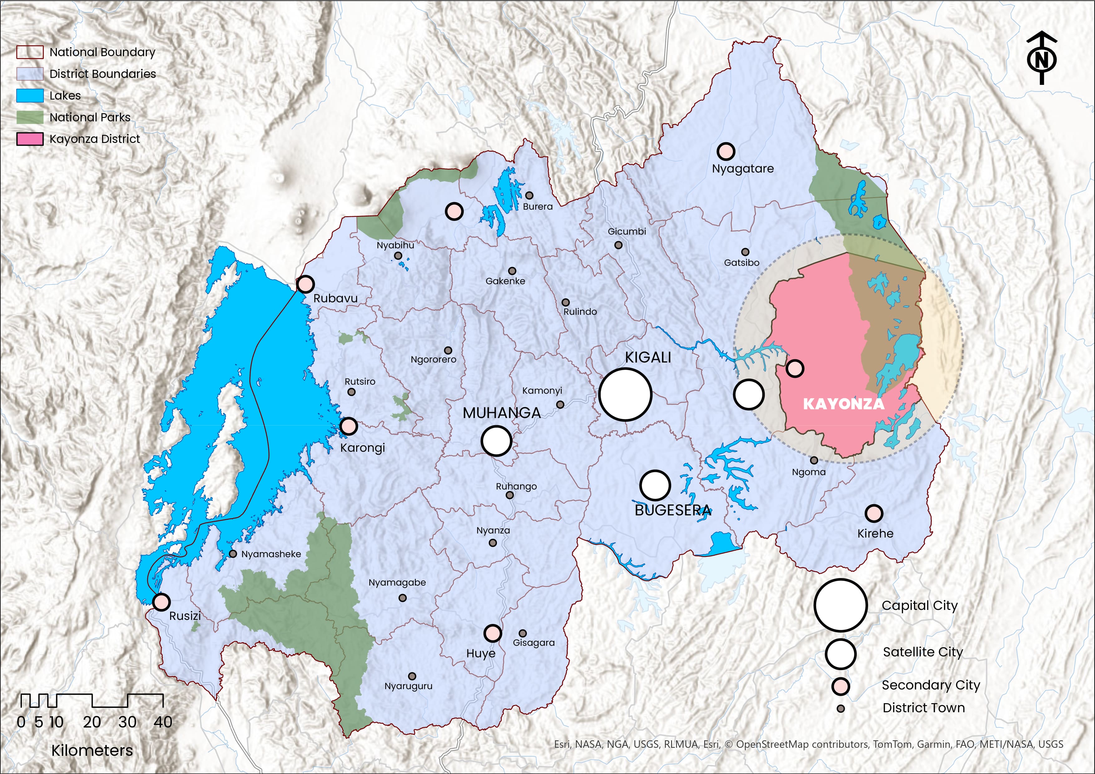 Geographical Location of Kayonza District
- 2. Kayonza DLUP
District Land Use Plan (DLUP):
Is a geographical or spatial strategic plan that translates the NLUDMP 2020–2050 into actionable framework at the district level, guiding the effective allocation and management of land and resources across all thematic sectors, for efficient, sustainable, and conflict-free land use to promote a balanced economy, environmental stewardship, and socio-economic transformation for both present and future generations.
Kayonza DLUP is a comprehensive spatial strategic plan developed to render the NLUDMP 2020-2050 into a localized and executable blueprint for sustainable land management in Kayonza District. The plan was elaborated through a consultant-led approach by Victorious Company Ltd between 2023 and 2024, commissioned and technically supervised by the NLA in collaboration with Kayonza District. It was prepared using a rigorous, participatory, and data-driven methodology that included consultations from the national level down to the local communities, extensive collection and analysis of both spatial and non-spatial data, and the integration of technical and social insights into a coherent planning framework.
At the core of Kayonza DLUP lies the District Economic Specialization, which identifies the district’s comparative advantages and informs its long-term vision toward 2050. This vision emphasizes sustainable urbanization, effective land utilization, and inclusive socio-economic transformation. The plan integrates population projections to ensure that land allocation and infrastructure development respond to both current and future needs. It further considers the urbanization and settlement hierarchy of Kayonza, from the main urban area to rural settlements, aligning with national spatial development strategies.
In line with the NLUDMP 2020–2050, the plan adopts recommended housing typologies, establishes the housing stock by zoning categories, and defines a Land Use Balance Sheet for 2050 to guide equitable and efficient allocation of land across thematic sectors. Additionally, it identifies key catalytic projects aimed at boosting economic growth, improving infrastructure, and enhancing service delivery.
Following its elaboration, the plan underwent multiple layers of technical review, public display, validation and approval, successfully passing through stages, including the Economic Commission, District Council, TAG, and the Economic Cluster, and is currently awaiting Cabinet approval. Kayonza DLUP will serve as a critical tool for guiding spatial development, promoting investment, and ensuring balanced, sustainable growth across the district.
3. Economic Specialization
| Economic Specialization | Why? |
|---|---|
| Tourism Development | Kayonza District is home to a significant portion of Akagera National Park and offers vibrant tourism opportunities built around Lake Muhazi’s eco-leisure experiences, as well as Rwanda’s rich cultural and historical heritage sites. |
| Mining Powerhouse | Kayonza District is home to the renowned Rwinkwavu Wolfram Mine and several other valuable mineral reserves. |
| Agri-Business and Livestock | Kayonza District features vast plains and fertile wetlands ideal for large-scale mechanized agriculture along with expansive grazing areas near Akagera National Park. |
| Commercial and Logistics Development | Kayonza is a strategic crossroads connecting expressways from Kagitumba (Uganda) and Rusumo (Tanzania), enhancing regional mobility and serving as a central hub for trade, logistics, and cross-border exchange. |
Kayonza District Economic Specialization
Kayonza District stands out as one of the most strategically endowed and economically dynamic districts in Rwanda’s Eastern Province, with an economic specialization shaped by its natural wealth, location, and regional connectivity. Tourism forms a cornerstone of its economy, as the district proudly hosts a significant portion of Akagera National Park, including its renowned South Gate in Rwinkwavu Sector serving as a key entry point for visitors seeking Rwanda’s premier wildlife experiences.
Complementing this is Lake Muhazi, whose tranquil shores offer great potential for eco-leisure, recreation, and high-end hospitality development. Beyond natural attractions, Kayonza also celebrates Rwanda’s cultural and historical heritage through diverse sites that enrich its tourism appeal. The district’s subsoil resources add another layer of economic strength, with the Rwinkwavu Wolfram Mine and other mineral deposits positioning Kayonza as a growing mining powerhouse contributing to national industrialization.
Agribusiness and livestock farming equally define the district’s economic identity. Its vast plains, fertile wetlands, and favorable climate provide ideal conditions for large-scale mechanized agriculture, while the proximity to Akagera National Park supports extensive livestock production. These factors collectively make Kayonza a vital agricultural and food production hub for the country. Moreover, its unique geographic position at the junction of the Eastern Expressway linking Rwanda to both Uganda through Kagitumba and Tanzania through Rusumo, elevates Kayonza into a major commercial and logistics corridor facilitating regional trade and integration.
Together, these interlinked economic sectors (tourism, mining, agriculture, livestock, and logistics) form the backbone of Kayonza’s development agenda and have inspired its forward-looking vision: “A Hub of Agri-Business, Tourism, and Mining in the Eastern Province.” This vision encapsulates Kayonza’s aspiration to transform its strategic advantages and natural potential into sustainable growth, job creation, and regional competitiveness by 2050.
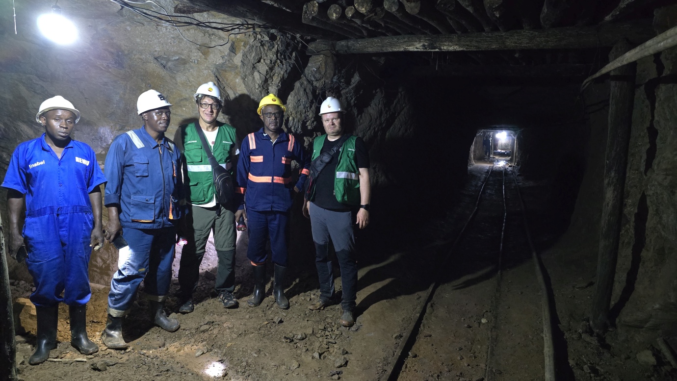 Wolfram Mining Site in Rwinkwavu Sector, Kayonza District
4. Vision
Vision of Kayonza District is to become:
A Hub of Agri-Business, Tourism, and Mining in the Eastern Province.
Kayonza District’s vision, reflects its goal to leverage natural resources, strategic location, and infrastructure to drive inclusive and sustainable economic growth. Through Kayonza DLUP, the district prioritizes efficient utilization of land to promote large-scale agriculture, livestock production, mining, and tourism. Its fertile plains and wetlands are reserved for mechanized farming and agro-industrial activities, while the proximity to Akagera National Park and Lake Muhazi fosters eco-tourism and conservation-led development. The district’s mineral wealth, especially the Rwinkwavu Wolfram Mine, contributes to Rwanda’s industrialization agenda by encouraging value addition and local processing. These priorities directly support Rwanda’s Vision 2050 and its goal of becoming an upper-middle-income country by 2035 and a high-income country by 2050.
This vision promotes balanced spatial growth by developing Kayonza Secondary City and supporting centers such as Rwinkwavu and Kabarondo. Improved transport and infrastructure support these developments. Due to its location along the Eastern Expressway, which links Rwanda to Uganda and Tanzania, the district is positioned as a key commercial and logistics corridor that facilitates regional trade and integration. Environmental sustainability remains central to its land use planning, with zones dedicated to reforestation, soil conservation, and wetland protection. Kayonza’s integrated approach, anchored in efficient land management, green growth, and value chain development, demonstrates how decentralized, land-based planning can accelerate Rwanda’s transformation into a modern, competitive, climate-resilient, high-income economy by 2050.
5. Population Projection
| District Population | 2012 | 2022 | 2035 | 2050 |
|---|---|---|---|---|
| Urban Population | 34,008 (9.9%) | 65,071 (14.2%) | 235,443 (39.7%) | 479,500 (60%) |
| Rural Population | 310,149 (90.1%) | 392,085 (85.8%) | 357,171 (60.3%) | 320,000 (40%) |
| Total Population | 344,157 | 457,156 | 592,614 | 799,500 |
Kayonza District Population Projection | Source: NISR (RHPC 5, 2022); NLA (NLUDMP 2020-2050; Kayonza DLUP)
The population of Kayonza District has shown a steady upward trajectory, reflecting both demographic growth and the district’s evolving urbanization dynamics. According to projections derived from the NISR (RHPC5, 2022) and the NLUDMP 2020–2050, the district’s total population is expected to rise from 344,157 in 2012 to approximately 799,500 by 2050. This growth is characterized by a significant shift from rural to urban living as urbanization and economic transformation continue to shape the district’s development.
In 2012, only 9.9% of the population lived in urban areas, with the vast majority (90.1%) residing in rural communities. By 2022, the urban population share had increased to 14.2%, and projections indicate that by 2035, nearly 39.7% of Kayonza District residents (about 235,443 people) will live in urban areas, while 60.3% will remain in rural settlements. By 2050, the district is expected to reach a transformative milestone where 60% of its population, approximately 479,500 people, will be urban dwellers, and 40% (about 320,000) will live in rural areas.
This urban shift is primarily driven by the growth of Kayonza Secondary City and the strengthening of Rurban Centers, which serve as local service and economic nodes. By 2035, Kayonza Secondary City is projected to host 198,268 inhabitants, while the three Rurban Centers: Kabarondo (18,702 inhabitants), Rwinkwavu (809 inhabitants), and Karubamba–Videwo (17,664 inhabitants), will collectively accommodate 37,175 residents. Moving toward 2050, the population of Kayonza Secondary City is expected to double to 400,000, and the Rurban Centers will collectively host 79,500 residents, distributed as Kabarondo (39,995 inhabitants), Rwinkwavu (1,731 inhabitants), and Karubamba–Videwo (37,775 inhabitants).
6. Urbanization and Settlements
| Settlements Hierarchy | - |
|---|---|
| Main Urban Area | Kayonza Secondary City |
| Rurban Centers (3) | Kabarondo, Rwinkwavu, Karubamba-Videwo |
| Rural Settlement Sites | 101 |
Source: NLA (NLUDMP 2020-2050; Kayonza DLUP)
According to Kayonza DLUP, the district's urbanization and settlements hierarchy is composed of a Secondary City, three Rurban Centers, and 101 Rural Settlement Sites, reflecting a deliberate effort to promote urban–rural integration and territorial balance.
At the top of the hierarchy is Kayonza Secondary City, envisioned as the district’s main urban growth pole and a strategic node in the national secondary city network. Kayonza Secondary City was introduced under the NLUDMP 2020–2050 as one of the three Secondary Cities (Phase II), alongside Karongi in the Western Province and Kirehe in the Eastern Province. Strategically located at the junction of the Eastern Expressway, Kayonza was designated to serve as a dynamic trade and logistics hub for the eastern corridor, while simultaneously supporting the tourism economy anchored in Akagera National Park. Its establishment reflects a deliberate national effort to promote balanced regional development, strengthen urban–rural linkages, and enhance economic competitiveness across the Eastern Province.
For Kayonza Secondary City, the NLUDMP 2020-2050 projected an urban footprint of 28 km² by 2035, expanding to 38 km² by 2050 to accommodate a population of 220,000 by 2035 and 400,000 by 2050. However, through the elaboration of the DLUP, this target was revised to 31.82 km² by 2050, in line with the principles of compact and vertical urban development. This adjustment reflects a move towards smart urban growth, prioritizing densification over horizontal expansion to prevent urban sprawl, preserve prime agricultural land, and promote efficient land utilization. The densification approach aligns directly with Rwanda’s national urbanization policy, which emphasizes sustainable, inclusive, and productive cities that drive economic transformation.
Following the Secondary City, three Rurban Centers (Kabarondo, Rwinkwavu, and Karubamba–Videwo) serve as intermediary nodes connecting urban and rural economies. While the NLUDMP 2020-2050 originally allocated 12.6 km² for these centers to accommodate 73,971 inhabitants by 2050, the DLUP expanded their total planned area to 29 km² to cater for a revised population projection of 79,500. This expansion was necessary to accommodate diversified land uses such as commercial zones, public infrastructure, industrial activities, and green spaces, ensuring that the Rurban Centers evolve into vibrant and self-sustaining towns supporting local economic specialization—especially tourism in Rwinkwavu, agribusiness in Kabarondo, and trade in Karubamba–Videwo.
At the rural level, the number of Planned Rural Settlement Sites was reduced from 145 (as proposed in the NLUDMP 2020-2050) to 101 in the DLUP, while maintaining a similar total land coverage of around 60 km². This reduction was guided by the principles of land optimization and consolidation, aiming to create more organized, service-accessible, and resilient rural settlements. Concentrating development in fewer, better-planned sites ensures efficient delivery of infrastructure and public services, reduces pressure on natural ecosystems, and supports integrated rural development—critical for sustaining livelihoods and reducing migration pressure on urban centers.
7. Housing Typologies according to the NLUDMP 2020-2050
-
Settlement Categories A+ A B C D Kayonza Secondary City 19% 40% 30% 7% 4% Rurban Centers (all) 52% 45% 2% 1% - Rural Settlement Sites 50% 50% - - - -
Housing Typologies for Kayonza District according to the NLUDMP 2020-2050
-
-
A+ stands for houses with only one floor (single-level).
-
A stands for houses with up to two floors.
-
B stands for houses with 3 to 4 floors.
-
C stands for houses with 5 to 9 floors.
-
D stands for houses with 10 to 22 floors, but can exceed this level under special conditions.
Source: NLA (NLUDMP 2020-2050; Kayonza DLUP)
The housing typologies for Kayonza District, as outlined in the NLUDMP 2020–2050, are strategically distributed to reflect the district’s settlement hierarchy and promote sustainable, efficient land use. In Kayonza Secondary City, housing is planned to consist of 19% A+ (single-level houses), 40% A (two-floor houses), 30% B (3–4 floor buildings), 7% C (5–9 floor buildings), and 4% D (10–22 floor buildings), highlighting a clear focus on densification and compact urban growth. In Rurban Centers, the structure remains predominantly low-rise, with 52% A+, 45% A, 2% B, and 1% C, balancing between urban functionality and rural character. Meanwhile, Rural Settlement Sites maintain a simpler residential pattern, with 50% A+ and 50% A, ensuring efficient land use while preserving agricultural and natural areas. This typological distribution supports inclusive and sustainable urbanization, minimizes land consumption, and strengthens the district’s capacity to accommodate its growing population while fostering livable and resilient communities.
8. Housing Stock by Zoning Categories
| Housing Category | Area (Km²) | Households |
|---|---|---|
| (R1, R1A, R1B) for A+ | 28.89 | 69,335 |
| R2 for A&B | 28.57 | 119,341 |
| R3 for C | 1.14 | 7,199 |
| R4 for D | 44.4 | 4,000 |
Kayonza District Housing Stock by 2050
-
R1 stands for Low Density Residential Zone.
-
R1A stands for Low Density Residential Densification Zone.
-
R1B stands for Rural Residential Zone.
-
R2 stands for Medium Density Residential - Improvement Zone.
-
R3 stands for Medium Density Residential - Expansion Zone.
-
R4 stands for High Density Residential Zone.
Source: NLA (NLUDMP 2020-2050; Kayonza DLUP)
The residential housing stock in Kayonza District, as projected in the DLUP by 2050, is strategically distributed across zoning categories to promote balanced and efficient urban growth while accommodating the district’s expanding population. Residential Zones: R1, R1A, and R1B, designated for A+ housing typologies, cover an area of 28.89 km² and are expected to accommodate 69,335 households, reflecting a focus on spacious living environments and controlled expansion in both urban and rural areas. The Medium Density Residential - Expansion Zone (R2), designed for A and B housing categories, spans 28.57 km² and will host the largest share of households (119,341) demonstrating the district’s commitment to compact, mixed-use urban development. The Medium Density Residential - Expansion Zone (R3), associated with C-type housing, occupies 1.14 km² with a projected 7,199 households, indicating a gradual transition toward more vertical, space-efficient living. Lastly, the High-Density Residential Zone (R4), reserved for D-type housing, extends over 44.4 km² and accommodates 4,000 households, ensuring adequate provision for future urban intensification. This zoning distribution highlights Kayonza’s strategic approach to sustainable settlement planning, balancing density, land optimization, and livability to support its long-term vision of becoming a hub of agri-business, tourism, and mining in the Eastern Province.
9. Planned Land Use Balance Sheet by 2050
Main Land Uses Categories Area (Km²) Percentage Agriculture & Livestock 1002.70 51.94% Forest & Conservation
473.99 24.55% Urbanization, Settlements & Infrastructure 139.18 7.21% Waterbodies, Protected Wetlands & their buffers 314.80 16.31% Kayonza District Planned Land Use Balance Sheet by 2050 | source: NLA (Kayonza DLUP)
The Planned Land Use Balance Sheet of Kayonza District by 2050, as established in Kayonza DLUP, reflects a spatial framework that strategically supports the district’s long-term vision of becoming a hub for agribusiness, tourism, mining, and trade and logistics within the Eastern Province. With 51.94% (1,002.70 km²) of land allocated to agriculture and livestock, the plan reinforces the district’s agribusiness potential by ensuring vast, productive agricultural zones that promote commercial farming, agro-processing, and value-chain integration. The allocation of 24.55% (473.99 km²) to forest and conservation areas complements this by maintaining environmental sustainability, providing ecosystem services, and enhancing the district’s tourism potential, particularly around natural and scenic landscapes near Akagera National Park. The 16.31% (314.80 km²) dedicated to waterbodies, wetlands, and their buffers not only protects key ecological systems but also supports eco-tourism and leisure-based investments, such as those planned around Lake Muhazi. Meanwhile, 7.21% (139.18 km²) allocated to urbanization, settlements, and infrastructure underlines the district’s growing urban character, with Kayonza Secondary City emerging as a trade and logistics hub strategically positioned along the Eastern Expressway.
Collectively, this land use balance aligns with national spatial planning principles under the NLUDMP 2020–2050, ensuring compact, efficient, and sustainable development. It demonstrates how Kayonza DLUP integrates environmental protection with economic diversification, enabling the district to drive regional trade, attract investment, and contribute significantly to Rwanda’s broader vision of achieving upper-middle-income status by 2035 and high-income status by 2050.
10. Catalytic Projects
| # | Projects |
|---|---|
| 1 | Redevelopment and Face-lift of Kayonza Roundabout (Mukarange Sector) |
| 2 | Development of a Modern Shopping Mall at Former District Offices (Mukarange Sector) |
| 3 | Development of Modern Markets in Mukarange, Kabarondo, Rwinkwavu, and Karubamba |
| 4 | Construction of Modern Bus Terminals in Mukarange, Kabarondo, Rwinkwavu, and Video-Karubamba |
| 5 | Land Readjustment and Plot Servicing for Key Urban Sites (Nyagatovu, Bwiza, Akinyenyeri, Cyinzovu, Karubamba, and Video) |
| 6 | Establishment of a Cultural Hub in Mukarange Sector |
| 7 | Development of Bypass Roads and Green Urban Corridors (Mukarange & Kabarondo) |
| 8 | Upgrading and Expansion of Water Supply Systems (Muhazi, Nyankora, Nasho-Ihema, and Lake Ihema WTPs) |
| 9 | Development of the Gatagara Light Industrial Zone (Mukarange Sector) |
| 10 | Construction of Modern Rice Milling and Maize Processing Facilities (Rwinkwavu & Mukarange Sectors) |
| 11 | Implementation of Large-Scale Irrigation Projects (Ndego, Rwinkwavu, Kabarondo, Murundi & Mwili Sectors) |
| 12 | Development of Eastern Lakes Eco-Tourism Destinations (Muhazi, Nasho, Rwakibali & Cyambwe Lakes) |
| 13 | Promotion of Cultural and Heritage Tourism (Murundi, Gahini, Rukara & Kawangire Sectors) |
| 14 | Development of Mountain Climbing and Cycling Trails (Mwiri, Gahini, Rukara, Ndego, Murundi & Rwinkwavu Sectors) |
| 15 | Construction of Rwinkwavu Stadium (Rwinkwavu Sector) |
Kayonza District Catalytic Projects | Source: NLA (Kayonza DLUP)
The catalytic projects outlined in Kayonza DLUP represent the backbone of the district’s transformation agenda toward 2050. They are strategically designed to unlock Kayonza District full potential as a regional hub for agribusiness, tourism, mining, trade, and logistics within the Eastern Province. Anchored in sustainable land use principles, these projects aim to enhance urban functionality, economic competitiveness, and environmental resilience. The transformation begins at the urban core, where projects such as the redevelopment of Kayonza Roundabout, the modernization of key markets, and the creation of a central shopping precinct will redefine the image of Kayonza Secondary City as a vibrant commercial and service center. Complementing these urban developments, the construction of modern bus terminals and green mobility corridors will improve accessibility, reduce congestion, and support inclusive mobility across the district. Likewise, land readjustment and plot servicing initiatives in Nyagatovu, Bwiza, Akinyenyeri, and Karubamba sites will enable orderly urban growth, ensure land optimization, and attract private investment in housing and real estate.
Beyond the urban core, the DLUP identifies catalytic projects that promote rural productivity, resource efficiency, and tourism diversification. The agro-industrial and irrigation development programs in areas such as Gatagara, Ndego, Rwinkwavu, and Kabarondo will significantly strengthen agricultural value chains and improve food security through mechanized farming, modern processing facilities, and sustainable water management. Simultaneously, the Eastern Lakes Eco-Tourism Initiative (centered on Lakes Muhazi, Nasho, and Rwakibali) along with the Cultural and Heritage Tourism Projects in Gahini, Rukara, and Murundi, will position Kayonza as a premier destination for leisure, culture, and nature-based tourism. Adventure and sports tourism circuits, including mountain climbing routes and the Rwinkwavu Stadium, further enrich the district’s tourism offerings. Together, these projects form a cohesive framework that links urban modernization with rural transformation, creating synergies between agriculture, tourism, and trade. Through these catalytic interventions, Kayonza District is set to emerge as a prosperous and resilient economic hub, driving Rwanda’s broader Vision 2050 goal of achieving high-income status through inclusive, sustainable, and spatially balanced development.
11. Consultative Validations & Approval
| Validation Stage | Date |
|---|---|
| District Council |
29th December 2023 |
| Technical Advisory Group (TAG) | 16th May 2024 |
| Economic Cluster | 22nd April 2025 |
| Cabinet |
Await |
Kayonza DLUP Consultative Validations & Approval
Kayonza DLUP underwent a comprehensive and multi-tiered consultative validation process designed to ensure its coherence with both local development priorities and Rwanda’s national strategic objectives. The process commenced with the District Council validation on 29th December 2023, where the plan received its first formal endorsement, confirming its consistency with the district’s spatial development vision and community aspirations.
Subsequently, the plan was presented to the TAG (a national-level forum bringing together experts from multiple ministries and agencies) which endorsed it on 16th May 2024. This critical review ensured that the DLUP was technically sound and aligned with sectoral frameworks across land use, infrastructure, environment, and economic development. The validation continued through the Economic Cluster on 22nd April 2025, chaired by the Ministry of Finance and Economic Planning (MINECOFIN) with the Ministry of Environment (MoE) as the lead institution, in collaboration with MININFRA and MINAGRI. This stage assessed the plan’s fiscal feasibility and policy integration within broader national development priorities. The final stage — Cabinet approval — is currently awaited, which marks the official endorsement of Kayonza DLUP as a legally binding instrument guiding sustainable urbanization, agribusiness, tourism, mining, and trade-led development across the district.
12. Accessibility of Kayonza DLUP
Following the approval of Kayonza DLUP by the District Council, it was promptly published online to enhance accessibility, and inclusive participation. The plan is now available through the NLA digital platforms, including the National Spatial Data Infrastructure (NSDI) Hub and the official NLA website, where anyone can conveniently access and explore it. This digital publication marks the full integration of Kayonza DLUP into the Land Administration Information System (LAIS), allowing users to visualize, identify, and analyze individual land parcels in relation to approved zoning and land use categories. Through this integration, the plan not only strengthens land governance and data-driven decision-making but also provides an interactive gateway to understanding the district’s spatial dynamics.
Kayonza DLUP is open to students, researchers, planners, implementers, public and private agencies, NGOs, humanitarian organizations, and the general public, serving as a vital resource for all stakeholders interested in the district’s development trajectory. Importantly, it stands as a strategic tool for investors, offering detailed insights into Kayonza District development potential, spatial opportunities, and sectoral priorities from urban growth and agribusiness to tourism, mining, and trade. By accessing the plan, stakeholders can better understand where and how Kayonza is growing, identify areas of opportunity, and align their initiatives with the district’s sustainable development vision.
For those wishing to explore the plan in detail, Kayonza DLUP Zoning Plan, Kayonza DLUP Report, and the Land Use Zoning Regulations supporting its implementation can be accessed through the following links:
Click the links below to explore more:
This article presents only the key highlights of Kayonza DLUP, offering a concise overview of its most significant features. If you would like to explore the DLUP of another district, please refer to the list below where districts are organized according to the urbanization & settlements hierarchy as designated by NLUDMP 2020-2050.
DLUPs for Satellite Cities' Districts
Bugesera DLUP
Muhanga DLUP
Rwamagana DLUP
DLUPs for Secondary Cities' Districts
Huye DLUPKarongi DLUP
Kirehe DLUP
Musanze DLUP
Nyagatare DLUP
Rubavu DLUP
Rusizi DLUP
DLUPs for Rural Districts
Burera DLUP
Gakenke DLUP
Gatsibo DLUP
Gicumbi DLUP
Gisagara DLUP
Kamonyi DLUP
Ngororero DLUP
Nyabihu DLUP
Nyamagabe DLUP
Nyamasheke DLUP
Nyanza DLUP
Nyaruguru DLUP
Ruhango DLUP
Rulindo DLUP
Rutsiro DLUP
REFERENCES
- 1. National Land Authority (NLA). (2020). National Land Use and Development Master Plan 2020–2050. Kigali, Rwanda: Republic of Rwanda. Available at: NLUDMP 2020-2050
- 2. National Land Authority (NLA). (2024). Kayonza District Land Use Plan (DLUP). Kigali, Rwanda: NLA / Republic of Rwanda. Available at: Kayonza DLUP
- 3. Kayonza District. Kayonza District Location / Overview. Eastern Province, Rwanda: Kayonza District Official Website. Available at: https://www.kayonza.gov.rw/
- 4. National Institute of Statistics of Rwanda (NISR). (2023). The Fifth Rwanda Population and Housing Census (RPHC5) – Main Indicators Report. Kigali, Rwanda: NISR. Available at: RPHC5, 2022
- 5. National Land Authority (NLA). (2021). National Spatial Data Infrastructure (NSDI) Hub – Geodata Platform. Kigali, Rwanda: NLA. Available at: https://geodata.rw/kayonza
- 6. National Land Authority (NLA). Land Use Plans Zoning Regulations. Kigali, Rwanda: 2024. Available at: Planned Land Use Zoning Regulations
Leave a Comment
Comments (0)