

A Vibrant hub of Mining Processing, Trade and Logistics
Muhanga District Land Use Plan (DLUP) paints a bold vision for the future of a district that truly sits at the heart of Rwanda. Serving as a national crossroads that connects Kigali with the west, south, and north, Muhanga District is positioned to become one of the country’s most dynamic growth poles. The DLUP provides a clear roadmap to 2050, showing how every piece of land, from fertile hillsides to vibrant city and centers, will be used wisely to fuel economic growth, protect the environment, and improve people’s lives.
Muhanga DLUP was developed between 2021 and 2023 by the National Land Authority (NLA) leveraging in-house expertise and reflects Rwanda's growing capacity to adopt home-grown solutions and data-driven planning. The plan turns the National Land Use and Development Master Plan (NLUDMP 2020–2050) to the district level, with strong local participation ensuring that national goals and community priorities go hand in hand.
At its core, Muhanga District envisions itself as a vibrant hub of mining processing, trade, and logistics — an industrial and commercial powerhouse that complements Kigali City while serving as a gateway to the west, north and south. The plan highlights mining, industry, logistics, trade, and MICE tourism as engines of transformation, while modern agriculture and sustainable settlements ensure that progress remains inclusive. By 2050, Muhanga District population is projected to surpass one million, calling for smarter, denser urban centers like Muhanga Satellite City and Remera Rurban Center, supported by 135 planned rural settlements.
The plan also balances growth and preservation — dedicating over half of its land to agriculture, a quarter to forests and conservation, and nearly 20% to urbanization and settlements. A series of catalytic projects, from modern industries and water treatment plants to an Olympic Stadium and upgraded infrastructure, will drive this transformation.
Fully validated and approved up to Cabinet level in 2023, Muhanga DLUP is now accessible online through NLA platforms, allowing everyone (from big investors to local citizens) to explore the future opportunities of Muhanga District through maps, zoning plans, and reports. More than just a plan, it’s a promise of a greener, more connected, and economically thriving district where growth and sustainability go hand in hand.
1. Muhanga District
Muhanga District, at the very heart of Rwanda, is a true crossroads that connects the country’s key regions, linking the west, south, north, and even the capital city (Kigali) to the east. Spanning 647.7 km², the district is home to 12 sectors, 63 cells, and 331 villages (Imidugudu), each contributing to its dynamic character. Muhanga is one of 8 districts of the Southern Province where it borders Kamonyi District to the east, while to the south it shares land with Ruhango District. On its western side, it opens to the breathtaking landscapes of Karongi and Ngororero Districts in the Western Province, and to the north, it touches the rolling hills of Gakenke District in the Northern Province. At its core lies Muhanga Satellite City, a fast-growing urban center nestled in the southeast, bridging communities across Shyogwe, Nyamabuye, Cyeza and Muhanga sectors, and extending towards Ruhango and Kamonyi. Beyond this urban heartbeat, the district unfolds into vast rural areas dotted with settlement centers, offering a mix of lively cityscapes and serene countryside that makes Muhanga both a gateway and a destination.
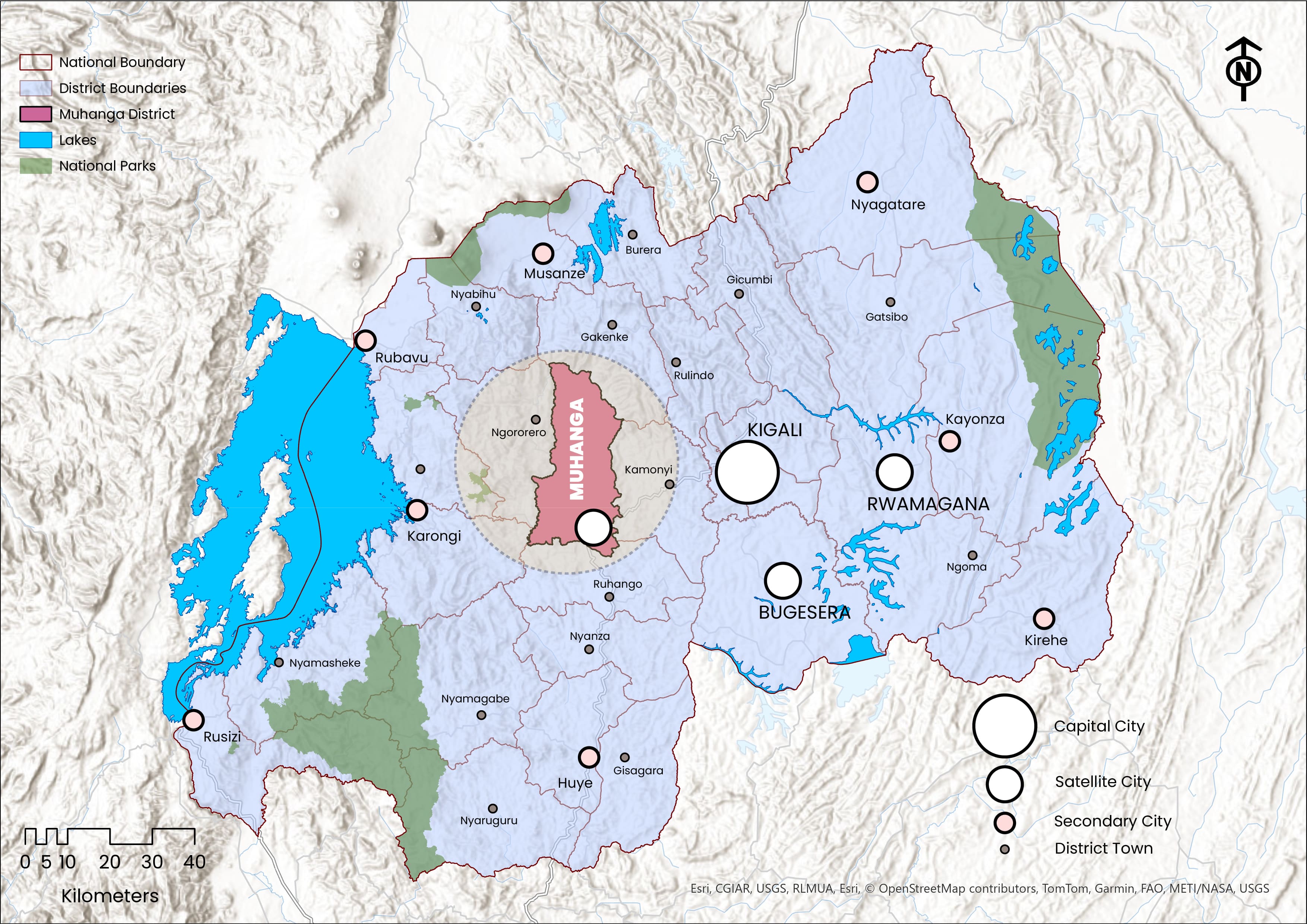 Geographical Location of Muhanga District
- 2. Muhanga DLUP
District Land Use Plan (DLUP):
Is a geographical or spatial strategic plan that translates the NLUDMP 2020–2050 into actionable framework at the district level, guiding the effective allocation and management of land and resources across all thematic sectors, for efficient, sustainable, and conflict-free land use to promote a balanced economy, environmental stewardship, and socio-economic transformation for both present and future generations.
Muhanga DLUP is a comprehensive spatial planning framework designed to localize and implement the NLUDMP 2020–2050 at the district level, ensuring sustainable and well-coordinated land management. Elaborated between 2021 and 2023 by the NLA in close collaboration with Muhanga District, the plan was developed through an In-House Capacity approach (without reliance on external consultants) demonstrating national ownership and institutional capability. Throughout its elaboration process, extensive consultations were held at every level, from national stakeholders and sectoral ministries to local communities, ensuring that the plan reflects both grassroots’ needs and national aspirations.
The process included comprehensive data collection covering spatial and statistical aspects, followed by in-depth analysis, report compilation, and mapping to produce the plan’s key deliverables. During this process, a new vision for Muhanga District was crafted (refers to the section 4 – Vision) in alignment with national transformation goals. Officially approved by the Cabinet in 2023, as detailed in the Validation and Approval section of this article, Muhanga DLUP establishes a long-term development framework extending to 2050, with a mid-term review in 2035, guiding balanced growth between urban and rural areas while promoting economic specialization, environmental sustainability, and resilient spatial development.
3. Economic Specialization
- 1. Mining and Quarrying – Harnessing abundant mineral and stone resources.
- 2. Industrial Development & Logistics.
- 3. Regional Trade Center of Rwanda.
- 4. MICE (Meetings, Incentives, Conferences, and Exhibitions).
Muhanga District is strategically positioned as one of Rwanda’s most promising growth poles, with its Land Use Plan highlighting a diversified economic specialization that reflects both local strengths and national aspirations. The district’s economy is anchored in mining and quarrying, where abundant mineral and stone resources support cement and related industries, meeting Rwanda’s growing demand for construction materials as urbanization accelerates. Complementing this, trade and logistics form another strong pillar, with Muhanga already functioning as Rwanda’s Regional Trade Center, linking Kigali to southern and western provinces and serving as a vital corridor to Burundi and the Democratic Republic of Congo. The district is also promoting industrial development and agro-processing, leveraging its strategic location along the national road network to reduce import dependency and strengthen value chains that benefit both urban and rural communities.
Beyond industry and trade, tourism — particularly Meetings, Incentives, Conferences, and Exhibitions (MICE) — is identified as a growth sector, with plans for hotels, convention facilities, and hospitality services that complement Kigali’s positioning while drawing on Muhanga’s cultural heritage and scenic landscapes. Equally important is agriculture, which remains a backbone of livelihoods and food security, with opportunities to modernize farming practices, expand livestock production, and integrate agricultural outputs into agro-industrial chains. Together, these specializations not only reinforce the District Vision of becoming a hub for mining, quarrying, and trade but also align with Rwanda’s Vision 2050 and NST2, which prioritize industrialization, trade facilitation, modern agriculture, and sustainable urbanization as engines of socio-economic transformation.
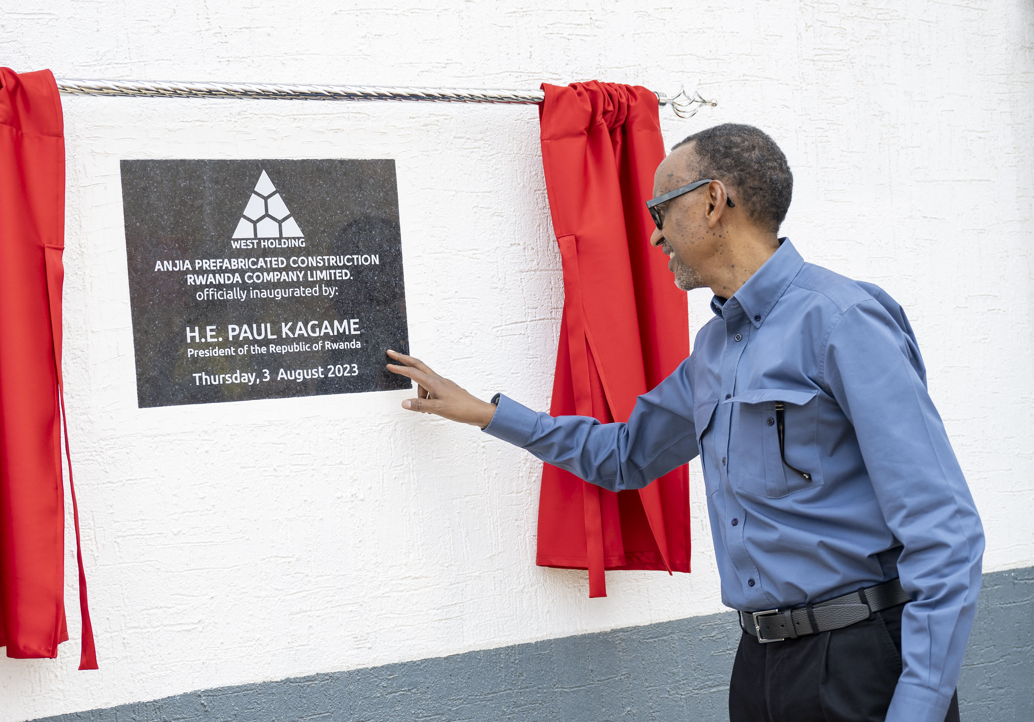 H.E. President Paul Kagame inaugurated Anjia Cement Factory | Muhanga, 3 August 2023
4. Vision
Vision of Muhanga District is to become:
A Vibrant hub of Mining Processing, Trade and Logistics.
Muhanga District envisions transforming into a dynamic hub of mining, quarrying, and trade, a vision drawn directly from its economic specializations and aligned with Rwanda’s national aspirations. Anchored in resource-based industries, modern trade, logistics, and agro-processing, the district seeks to evolve into a satellite city of Kigali, serving as both an industrial powerhouse and a regional gateway to neighboring markets. This vision is not limited to economic growth alone; it also emphasizes the creation of a modern urban fabric, efficient transport corridors, and sustainable infrastructure while safeguarding natural resources. Ultimately, Muhanga aspires to balance industrial dynamism with environmental stewardship and improved quality of life, making it a resilient and inclusive growth pole within Rwanda’s Vision 2050 framework.
5. Population Projection
| District Population | 2012 | 2022 | 2035 | 2050 |
|---|---|---|---|---|
| Urban Population | - | 87,252 (24.3%) | 454,575 (77.8%) | 826,500 (80.5%) |
| Rural Population | - | 271,181 (75.7%) | 129,628 (22.2%) | 200,000 (19.5%) |
| Total Population | 319,141 | 358,433 | 584,203 | 1,026,500 |
Muhanga District Population Projection | Source: NISR (RHPC 5, 2022); NLA, 2023
Muhanga DLUP builds on Rwanda’s national demographic trends, projecting substantial population growth. From 319,141 residents in 2012 to 358,433 in 2022, the district has demonstrated steady growth. Projections anticipate a near doubling by 2035, reaching 584,203 inhabitants, and more than tripling to 1,026,500 people by 2050. This rapid demographic shift underscores the urgent need for structured land use planning, infrastructure expansion, and sustainable settlement strategies.
The projections also reveal a significant urbanization trajectory.
In 2022, urban dwellers represented only 24.3% (87,252 people), while the majority — 75.7% (271,181 people) — lived in rural areas. However, by 2035 the balance shifts dramatically, with 454,575 residents (77.8%) projected to live in urban centers and only 129,628 (22.2%) remaining in rural settings. By 2050, urbanization reaches its peak with over 826,500 people (≈80.5%) living in towns, while the rural population reduces to around 200,000 (≈19.5%). This trend positions Muhanga as a rapidly urbanizing district, requiring innovative solutions for housing, infrastructure, and public services.
6. Urbanization and Settlements
| Muhanga Settlement Hierarchy | - |
|---|---|
| Main Urban Area | Muhanga Satellite City |
| Rurban Center (1) | Remera Rurban Center |
| Rural Settlement Sites | 135 |
Source: NLA (NLUDMP 2020-2050; Muhanga DLUP)
Muhanga DLUP presents a forward-looking urbanization and settlement framework anchored on Muhanga Satellite City, strategically located in the southeast of the district, stretching across the sectors of Nyamabuye, Shyogwe, Cyeza, and part of Muhanga. Sharing boundaries with Ruhango District to the south and Kamonyi District to the east, Muhanga Satellite City was introduced by the NLUDMP 2020–2050 to play a significant role in supporting the City of Kigali through industrialization, trade, and logistics. It also forms part of Rwanda’s “Golden Triangle,” alongside Kigali, Rwamagana, and Bugesera, envisioned to drive national urban and economic transformation. Complementing this growth, Remera Rurban Center has been designated as the district’s sole rurban center, situated in the central-northern part of the district within Kiyumba and Kabacuzi Sectors along the Remera–Nyabikenye corridor.
This hybrid settlement model is designed to promote in-situ urbanization, offering urban opportunities, and boosting the local economy through community-driven growth. Together, Muhanga Satellite City and Remera Rurban Center will accommodate the district’s projected urban population increase while ensuring balanced development. In parallel, the DLUP expands rural settlement planning from the 91 sites proposed by the NLUDMP to 135 planned rural settlements, aimed at accommodating the growing rural population and supporting rural livelihoods such as agriculture, forestry, and mining, thereby ensuring inclusive development across both urban and rural communities.
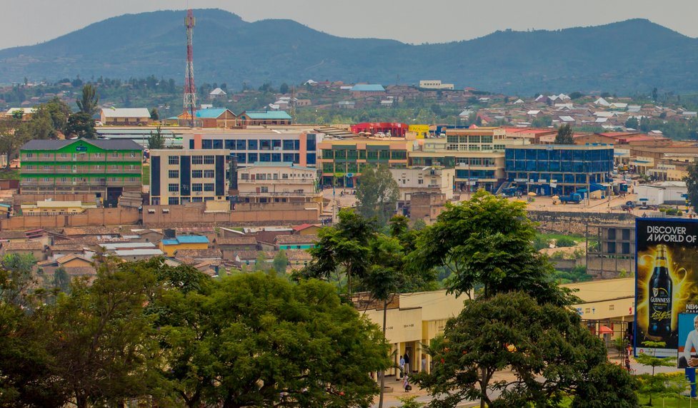 Muhanga Satellite City Tody | Source: (Top Africa News)
7. Housing Typologies according to NLUDMP 2020-2050
-
Settlement Categories A+ A B C D Muhanga Satellite City 10% 35% 35% 10% 10% Remera Rurban Center 52% 45% 2% 1% - Rural Settlement Sites 50% 50% - - - -
Housing Typologies for Muhanga District according to the NLUDMP 2020-2050
-
-
A+ stands for houses with only one floor (single-level).
-
A stands for houses with up to two floors.
-
B stands for houses with 3 to 4 floors.
-
C stands for houses with 5 to 9 floors.
-
D stands for houses with 10 to 22 floors, but can exceed this level under special conditions.
Source: NLA (NLUDMP 2020-2050; Muhanga DLUP)
According to the NLUDMP 2020–2050, housing typology in Muhanga District is strategically distributed across its urban and rural centers to ensure orderly growth and balanced development. Muhanga Satellite City will feature a diverse housing mix, with 10% in the A+ category (single-level houses), 35% in category A (up to two floors), 35% in category B (3–4 floors), 10% in category C (5–9 floors), and 10% in category D (10–22 floors, with possible conditional exceeding). In contrast, Remera Rurban Center will primarily emphasize low-rise housing, with 52% of units in A+ and 45% in A, alongside only 2% in B and 1% in C, and no provision for D. Meanwhile, the 135 planned rural settlement sites will maintain strictly low-rise housing standards, with an even split of 50% A+ and 50% A, prohibiting higher categories to preserve rural character. This typology reflects a deliberate planning approach: encouraging vertical growth in urban cores while maintaining horizontal, low-rise housing in rural areas, aligning settlement form with both functional and cultural needs.
8. Housing Stock by Zoning Categories
| Housing Category | Area (Km²) | % | Households |
|---|---|---|---|
| R1 | 1.56 | 1.78 | 4,568 |
| R1A | 4.23 | 4.80 | 12,318 |
| R1B | 68.82 | 78.80 | 202,221 |
| R2 | 2.13 | 2.42 | 6,210 |
| R3 | 6.45 | 7.40 | 18,990 |
| R4 | 0.7 | 0.80 | 2,053 |
| C1 & C3 | 3.47 | 4 | 10,265 |
Muhanga District Housing Stock by 2050 | Source: NLA (Muhanga DLUP)
By 2050, the housing stock of Muhanga District will be organized into a well-structured framework that balances rural inclusivity with urban densification, aligned to sustainable growth needs. The largest share will be in R1B Rural Residential Zones, covering 78.80% (68.82 km²) and accommodating 202,221 households, intended mainly for rural housing or, when in urban areas, placed on the outskirts to ensure inclusivity and orderly expansion. R1A Low-Density Residential Densification Zones, taking up 4.80% (4.23 km²) for 12,318 households, are designated as standard urban residential areas, while R1 Low-Density Residential Zones, covering 1.78% (1.56 km²) for 4,568 households, will serve as VIP residential areas within the urban core. R2 Medium-Density Improvement Zones, occupying 2.42% (2.13 km²) with 6,210 households, focus on upgrading informal settlements through improved housing and infrastructure.
Meanwhile, R3 Medium-Density Residential Expansion Zones, spread over 7.40% (6.45 km²) for 18,990 households, will support controlled urban growth in expansion areas. For compact, vertical living, R4 High-Density Residential Zones are planned on 0.80% (0.7 km²), hosting 2,053 households in high-rise apartments. Additionally, C1 and C3 Commercial Zones, covering 4% (3.47 km²) to accommodate 10,265 households, will integrate mixed-use residential and commercial spaces, fostering vibrant business-oriented communities. Collectively, this housing structure provides a clear hierarchy of settlement types—rural, urban, upgrading, expansion, and high-density—ensuring that Muhanga District’s urbanization remains inclusive, resilient, and sustainable by 2050.
8. Planned Land Use Balance Sheet by 2050
Main Land Uses Categories Area (Km²) Percentage Agriculture & Livestock 345.42 52.95% Forest & Conservation
167.24 25.57% Urbanization, Settlements & Infrastructure 127.95 19.58% Waterbodies, Protected Wetlands & their buffers 488.36 0.75% Muhanga District Planned Land Use Balance Sheet 2050 | Source: NLA (Muhanga DLUP)
The planned Land Use Balance Sheet for Muhanga District reflects a strategic approach to balancing productivity, conservation, and development in line with the district’s long-term vision. The largest share of land, 345.42 km² (52.95%), is dedicated to agriculture, livestock, and unprotected wetlands with their buffers, recognizing the central role of farming and livestock in sustaining livelihoods and ensuring food security. The second category, forest and conservation areas covering 167.24 km² (25.57%), integrates plantation zones, afforestation programs, high-slope areas designated for reforestation, natural forests, open spaces, eco-tourism zones, and even controlled mining areas, all of which are vital for environmental protection and climate resilience.
Urban growth and service delivery are also well catered for, with 127.95 km² (19.58%) allocated to urbanization, settlements, and infrastructure, encompassing residential neighborhoods, commercial hubs, public facilities, utilities, transportation networks, industrial zones, and other critical infrastructure that supports social and economic development. Finally, 4.88 km² (0.75%) is designated for waterbodies, protected wetlands, and their buffers, ensuring the preservation of rivers and wetlands as ecological assets and natural flood control systems. Together, this planned distribution demonstrates Muhanga’s commitment to sustainable land management by balancing agricultural productivity, environmental conservation, and urban development, while safeguarding critical ecosystems.
9. Catalytic Projects
| # | Projects |
|---|---|
| 1 | Construction of industries such as cement, tiles, and cover bed manufacturing plants. |
| 2 | Development of a five-star hotel in Muhanga Satellite City. |
| 3 | Construction of an Olympic Stadium in Shyogwe Sector. |
| 4 | Establishment of Kagaga Water Treatment Plant in Cyeza Sector. |
| 5 | Construction of Muguramo Water Treatment Plant. |
| 6 | Upgrading the existing Muhanga dump site into a modern landfill. |
| 7 | Development of modern markets in Muhanga Satellite City and Remera Rurban Center. |
| 8 | Elaboration and implementation of Physical Plans in all residential zones. |
| 9 | Construction and rehabilitation of key roads to improve mobility, logistics, and connectivity within the district and beyond |
Muhanga District Catalytic Projects | Source: NLA (Muhanga DLUP)
Muhanga DLUP identifies a set of catalytic projects designed to accelerate the district’s transformation into a dynamic, sustainable, and economically vibrant growth pole. These flagship initiatives are strategically aligned with the district’s economic specialization and its vision of becoming a modern urban and industrial hub complementing Kigali. Key among them is the establishment of industrial facilities for cement, tiles, and cover-bed production, capitalizing on the district’s rich mineral resources and supporting Rwanda’s construction and infrastructure growth. The plan also envisions a five-star hotel in Muhanga, positioning the district as a secondary tourism and MICE (Meetings, Incentives, Conferences, and Exhibitions) destination. The proposed Olympic Stadium in Shyogwe Sector will not only promote sports and recreation but also attract national and regional events, enhancing the district’s social and economic vitality.
In parallel, Kagaga and Muguramo Water Treatment Plants are critical infrastructure projects aimed at ensuring sustainable water supply to meet rising urban and industrial demand. Environmental sustainability is further supported through the upgrade of the existing Muhanga dump site into a modern landfill and recycling facility, advancing waste management and circular economy practices. To strengthen trade and local commerce, the DLUP proposes the development of modern markets in Muhanga Satellite City and Remera Rurban Center, improving business efficiency and livelihoods. Complementing these initiatives, the plan emphasizes the elaboration and implementation of physical plans in all residential zones to ensure orderly urbanization, and the construction and rehabilitation of roads to improve connectivity within the district and to national economic corridors. Collectively, these catalytic projects are designed to stimulate investment, create jobs, enhance service delivery, and drive sustainable economic development, positioning Muhanga as a model of balanced industrialization and urban transformation in Rwanda.
10. Consultative Validations & Approval
| Validation Stage | Date |
|---|---|
| Technical Advisory Group (TAG) |
24th April 2022 |
| District Council | 26th May 2022 |
| Economic Cluster | 10th September 2022 |
| Cabinet |
11th September 2023 |
Muhanga DLUP Consultative Validations & Approval
Muhanga DLUP underwent a comprehensive, multi-tiered consultative validation process that ensured its alignment with both local priorities and national development goals. The approval journey began on 24th April 2022, when the plan was first reviewed and endorsed by the Technical Advisory Group (TAG) — a national-level body composed of experts and representatives from various ministries and sectors. This stage was crucial in verifying that the plan effectively integrated all sectoral projects and long-term strategies across key areas such as environment, agriculture, infrastructure, and economic development.
Following this technical validation, the plan advanced to the District Council, which approved it on 26th May 2022, confirming its coherence with community needs and the district’s development vision. The process then continued to the Economic Cluster on 10th September 2022, chaired by the Ministry of Finance and Economic Planning (MINECOFIN), with the Ministry of Environment (MoE) as the project lead and MININFRA and MINAGRI as key implementing ministries. This stage evaluated the plan’s financial sustainability and strategic alignment with the National Strategy for Transformation. Finally, after fulfilling all technical, financial, and policy requirements, the Muhanga DLUP was officially approved by the Cabinet on 11th September 2023, marking the culmination of its validation journey and granting it full legal authority for implementation as a roadmap for sustainable and inclusive development in Muhanga District.
11. Accessibility of Muhanga DLUP
Following its approval by the District Council, Muhanga DLUP was promptly published online to ensure transparency, accessibility, and public engagement. The plan is now available through the NLA digital platforms, including the NSDI Hub and the NLA official website, where anyone interested can easily access it. This digital publication signifies the full integration of the DLUP into the Land Administration Information System (LAIS) — allowing citizens, planners, investors, and policymakers to identify and analyze their individual land parcels in relation to their planned zoning and land use categories. This integration enhances land governance and data-driven decision-making and empowers local communities by making spatial information openly available.
For those wishing to explore the plan in detail, Muhanga DLUP Zoning Plan, Muhanga DLUP Report, and the Land Use Zoning Regulations supporting its implementation can be accessed through the following links:
Click the links below to explore more:
This article presents only the key highlights of Muhanga DLUP, offering a concise overview of its most significant features. If you would like to explore the DLUP of another district, please refer to the list below where districts are organized according to the urbanization & Settlements hierarchy as designated by NLUDMP 2020-2050.
DLUPs for Satellite Cities' Districts
Bugesera DLUP
Muhanga DLUP (ACTIVE)
Rwamagana DLUP
DLUPs for Secondary Cities' Districts
Huye DLUPKarongi DLUP
Kirehe DLUP
Musanze DLUP
Nyagatare DLUP
Rubavu DLUP
Rusizi DLUP
DLUPs for Rural Districts
Burera DLUP
Gakenke DLUP
Gatsibo DLUP
Gicumbi DLUP
Gisagara DLUP
Kamonyi DLUP
Ngororero DLUP
Nyabihu DLUP
Nyamagabe DLUP
Nyamasheke DLUP
Nyanza DLUP
Nyaruguru DLUP
Ruhango DLUP
Rulindo DLUP
Rutsiro DLUP
REFERENCES
- 1. National Land Authority (NLA). (2020). National Land Use and Development Master Plan 2020–2050. Kigali, Rwanda: Republic of Rwanda. Available at: NLUDMP 2020-2050
- 2. National Land Authority (NLA). (2023). Muhanga District Land Use Plan (DLUP). Kigali, Rwanda: NLA / Republic of Rwanda. Available at: Muhanga DLUP
- 3. Muhanga District. Muhanga District Location / Overview. Southern Province, Rwanda: Muhanga District Official Website. Available at: https://www.muhanga.gov.rw/
- 4. National Institute of Statistics of Rwanda (NISR). (2023). The Fifth Rwanda Population and Housing Census (RPHC5) – Main Indicators Report. Kigali, Rwanda: NISR. Available at: RPHC5, 2022
- 5. National Land Authority (NLA). (2021). National Spatial Data Infrastructure (NSDI) Hub – Geodata Platform. Kigali, Rwanda: NLA. Available at: https://geodata.rw/muhanga
- 6. National Land Authority (NLA). Land Use Plans Zoning Regulations. Kigali, Rwanda: 2024. Available at: Planned Land Use Zoning Regulations
Leave a Comment
Comments (0)